Chest opened
+${chestReward.xp} XP
Explorer
NOUVEAU ×${chestReward.collectible.quantity}
tapez pour fermer
Chest locked

Open chests in the app

Around Us is built for your phone — chests unlock when you walk, explore and capture nearby places.

Enable Location

We need your location to show you interesting places around you

Discover nearby places

Find interesting locations and hidden gems around you

Precise directions

Get accurate directions and distances to places

Your location is never shared with other users. It's only used when you tap the location button.

Log in to your account

Start exploring — it's free

Trusted by 72,881 travelers worldwide

Continue with Google
Continue with Apple
or

We will send you a code to connect

By continuing, you accept our Terms and Conditions and our Privacy Policy

Check your inbox

We've sent a pincode in your inbox. Please enter the code below.

Mont du Saule
Discussion Reviews Photo
20+ Popularity

Mont du Saule, Mountain summit in Mayenne, France.

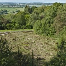
Mont du Saule is a mountain summit in the Mayenne region that offers views across neighboring valleys and higher elevations nearby. The area is mostly open with clear sightlines in several directions.

The summit served as an important landmark for travelers crossing the region over many centuries. This role shaped the landscape and still leaves traces in the local geography today.

The name Mont du Saule comes from the willow trees that grow across this region and shape the local landscape. Visitors can feel this connection to the land today while walking around the summit.

The hike requires sturdy walking shoes and plenty of water, as there are no facilities along the way or at the summit. Plan enough time and check local conditions before you go.

The composition of the ground and vegetation shifts noticeably with each season, creating different impressions on every visit. These natural changes make each hike feel like a fresh experience.

The community of curious travelers

AroundUs brings together thousands of curated places, local tips, and hidden gems, enriched daily by 60,000 contributors worldwide.

Start exploring
GPS coordinates
48.35660,-0.38376
Latest update
December 15, 2025 13:23
Around this place
Château de Hauteville
France

Château de Hauteville

7.8 km
Château de Montesson
France

Château de Montesson

11.6 km
Château du Grand Coudray
France

Château du Grand Coudray

7.7 km
Église Saint-Jean-Baptiste de Javron-les-Chapelles
France

Église Saint-Jean-Baptiste de Javron-les-Chapelles

7.6 km
Clocher de l'ancienne église Saint-Georges de Villaines-la-Juhel
France

Clocher de l'ancienne église Saint-Georges de Villaines-la-Juhel

7.6 km
Logis du Bois
France

Logis du Bois

10.6 km
Réserve naturelle régionale des landes et tourbière des Égoutelles
France

Réserve naturelle régionale des landes et tourbière des Égoutelles

9.5 km
Église Notre-Dame du Ham
France

Église Notre-Dame du Ham

2.6 km
Église Saint-Pierre-et-Saint-Paul de Courcité
France

Église Saint-Pierre-et-Saint-Paul de Courcité

11.4 km
Église Saint-Pierre d'Hardanges
France

Église Saint-Pierre d'Hardanges

2.6 km
Église Saint-Martin de Montreuil (Montreuil-Poulay)
France

Église Saint-Martin de Montreuil (Montreuil-Poulay)

10.8 km
Église Saint-Pierre et Saint-Paul du Horps
France

Église Saint-Pierre et Saint-Paul du Horps

7.2 km
Église Saint-Pierre-et-Saint-Paul de Charchigné
France

Église Saint-Pierre-et-Saint-Paul de Charchigné

7 km
Église Saint-Martin de Chevaigné-du-Maine
France

Église Saint-Martin de Chevaigné-du-Maine

9 km
Église Saint-Médard
France

Église Saint-Médard

10 km
Église Saint-Georges de Villaines-la-Juhel
France

Église Saint-Georges de Villaines-la-Juhel

7.8 km
Église Saint-Martin de Marcillé-la-ville
France

Église Saint-Martin de Marcillé-la-ville

10 km
Église Saint-Gervais-et-Saint-Protais de Champgenéteux
France

Église Saint-Gervais-et-Saint-Protais de Champgenéteux

7.5 km
Église Saint-Pierre-et-Saint-Paul de Poulay
France

Église Saint-Pierre-et-Saint-Paul de Poulay

10.1 km
Église de Courberie de Lassay-les-Châteaux
France

Église de Courberie de Lassay-les-Châteaux

10.5 km
Église Saint-Calais de Crennes-sur-Fraubée
France

Église Saint-Calais de Crennes-sur-Fraubée

8.1 km
Église Saint-Ouen du Ribay
France

Église Saint-Ouen du Ribay

3.5 km
Église Saint-Martin de Loupfougères
France

Église Saint-Martin de Loupfougères

3.3 km
Église Saint-Nicolas de Trans
France

Église Saint-Nicolas de Trans

10.7 km
Église Saint-Sulpice de Villepail
France

Église Saint-Sulpice de Villepail

9.7 km
Chapelle de Charchigné
France

Chapelle de Charchigné

7.4 km
Église Notre-Dame-de-l'Annonciation de La Chapelle-au-Riboul
France

Église Notre-Dame-de-l'Annonciation de La Chapelle-au-Riboul

5.7 km
Église Notre-Dame-de-l'Assomption des Chapelles
France

Église Notre-Dame-de-l'Assomption des Chapelles

10.4 km
Show the full map
Reviews
Share your experience

No review yet

Discussions
Start a discussion...

No discussion yet

« Mont du Saule - Mountain summit in Mayenne, France » is provided by Around Us (aroundus.com). Images and texts are derived from Wikimedia project under a Creative Commons license. You are allowed to copy, distribute, and modify copies of this page, under the conditions set by the license, as long as this note is clearly visible.

Discover hidden gems everywhere you go!

From secret cafés to breathtaking viewpoints, skip the crowded tourist spots and find places that match your style. Our app makes it easy with voice search, smart filtering, route optimization, and insider tips from travelers worldwide. Download now for the complete mobile experience.

Around Us App Screenshot

A unique approach to discovering new places

Le Figaro

All the places worth exploring

France Info

A tailor-made excursion in just a few clicks

20 Minutes

Around Us
Travel Guide & Maps
Download

Send to your phone

QR Code
1

Open the camera app on your mobile.

2

Point at the QR code with your camera. A notification will appear.

3

Tap the notification to open the link.