Enable Location

We need your location to show you interesting places around you

Discover nearby places

Find interesting locations and hidden gems around you

Precise directions

Get accurate directions and distances to places

Your location is never shared with other users. It's only used when you tap the location button.

Fortress of Ključ

Log in to your account

Start exploring — it's free

Trusted by 62,458 travelers worldwide

Continue with Google
Continue with Apple
or

We will send you a code to connect

By continuing, you accept our Terms and Conditions and our Privacy Policy

Check your inbox

We've sent a pincode in your inbox. Please enter the code below.

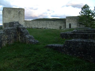
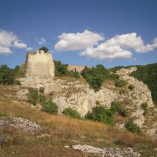
Fortress of Ključ, Medieval fortress in Ključ, Bosnia and Herzegovina

The Fortress of Ključ sits on a steep rocky slope at 521 meters (1,710 feet) elevation, overlooking the Sana River valley with three connected defensive sections. The structure includes a castle-town, the Tabor fortification, and the Ljubica tower that worked together as an integrated defense system.

The fortress was built during the medieval period and played a key role in controlling Bosnian territories across centuries. In 1463, it served as the final stronghold for King Stjepan Tomašević before Ottoman forces captured the medieval kingdom.

The name Ključ means 'key' in the local language, reflecting how this fortress controlled the main passages through the valley. The layout of the three sections shows how defenders needed to protect against threats from multiple directions.

The site demands moderate fitness as it sits on a steep slope with uneven paths throughout the ruins. Sturdy footwear is essential, and checking weather conditions before visiting is wise since elevation and exposure can present challenges.

Archaeological excavations uncovered Roman-era foundations beneath the medieval structures, revealing military occupation spanning multiple centuries. This layering of different periods makes the site an uncommon example of continuous fortification in Southeast Europe.

The community of curious travelers

AroundUs brings together thousands of curated places, local tips, and hidden gems, enriched daily by 60,000 contributors worldwide.

Start exploring
GPS coordinates
44.53743,16.78619
Latest update
December 14, 2025 18:10
Around this place
Gomionica Monastery
Bosnia and Herzegovina

Gomionica Monastery

23.6 km
Krupa na Vrbasu Monastery
Bosnia and Herzegovina

Krupa na Vrbasu Monastery

29 km
Temple of Saint Sava in Mrkonjić Grad
Bosnia and Herzegovina

Temple of Saint Sava in Mrkonjić Grad

27.9 km
Dabar Cave
Bosnia and Herzegovina

Dabar Cave

22.5 km
Hrustovačka pećina
Bosnia and Herzegovina

Hrustovačka pećina

16.5 km
Hamzibeys mosque
Bosnia and Herzegovina

Hamzibeys mosque

27 km
Monument to Korčanica
Bosnia and Herzegovina

Monument to Korčanica

32.2 km
Saints Philip and James Church, Mrkonjić Grad
Bosnia and Herzegovina

Saints Philip and James Church, Mrkonjić Grad

27.1 km
Bočac Fortress
Bosnia and Herzegovina

Bočac Fortress

29.7 km
Gradski stadion Luke
Bosnia and Herzegovina

Gradski stadion Luke

27.6 km
Ensemble commémoratif de Šušnjar
Bosnia and Herzegovina

Ensemble commémoratif de Šušnjar

26.6 km
Skakavac Waterfall
Bosnia and Herzegovina

Skakavac Waterfall

25 km
Église Saint-Nicolas de Krupa na Vrbasu
Bosnia and Herzegovina

Église Saint-Nicolas de Krupa na Vrbasu

25.9 km
Église en bois de l'Ascension de Kola
Bosnia and Herzegovina

Église en bois de l'Ascension de Kola

29.6 km
Tito’s train at Oštrelj
Bosnia and Herzegovina

Tito’s train at Oštrelj

31.1 km
Erscheinungskirche Gerzovo
Serbia

Erscheinungskirche Gerzovo

30.3 km
Église du Linceul-de-la-Mère-de-Dieu d'Agino Selo
Bosnia and Herzegovina

Église du Linceul-de-la-Mère-de-Dieu d'Agino Selo

32.4 km
Mariä-Entschlafens-Kirche (Donji Vrbljani)
Bosnia and Herzegovina

Mariä-Entschlafens-Kirche (Donji Vrbljani)

20.8 km
Mosquée Hamidija
Bosnia and Herzegovina

Mosquée Hamidija

27.1 km
Église de l'Ascension de Kola
Bosnia and Herzegovina

Église de l'Ascension de Kola

30.5 km
Hram Blagovijesti presvete Bogorodice
Bosnia and Herzegovina

Hram Blagovijesti presvete Bogorodice

22.3 km
Crkva Klisina
Bosnia and Herzegovina

Crkva Klisina

17.9 km
Mosque Trnova
Bosnia and Herzegovina

Mosque Trnova

30.9 km
Église de la Nativité-de-la-Mère-de-Dieu de Mrkonjić Grad
Bosnia and Herzegovina

Église de la Nativité-de-la-Mère-de-Dieu de Mrkonjić Grad

27.2 km
Musée du Conseil anti-fasciste d'État pour la libération nationale de la Bosnie-Herzégovine
Bosnia and Herzegovina

Musée du Conseil anti-fasciste d'État pour la libération nationale de la Bosnie-Herzégovine

27.1 km
Église Saint-Pantaléon de Dabrac
Bosnia and Herzegovina

Église Saint-Pantaléon de Dabrac

29.7 km
Grebenska Klisura
Bosnia and Herzegovina

Grebenska Klisura

27.9 km
Mosque of Bosnian muhajirs
Bosnia and Herzegovina

Mosque of Bosnian muhajirs

26.1 km
Show the full map
« Fortress of Ključ - Medieval fortress in Ključ, Bosnia and Herzegovina » is provided by Around Us (aroundus.com). Images and texts are derived from Wikimedia project under a Creative Commons license. You are allowed to copy, distribute, and modify copies of this page, under the conditions set by the license, as long as this note is clearly visible.

Discover hidden gems everywhere you go!

From secret cafés to breathtaking viewpoints, skip the crowded tourist spots and find places that match your style. Our app makes it easy with voice search, smart filtering, route optimization, and insider tips from travelers worldwide. Download now for the complete mobile experience.

Around Us App Screenshot

A unique approach to discovering new places

Le Figaro

All the places worth exploring

France Info

A tailor-made excursion in just a few clicks

20 Minutes

Around Us
Travel Guide & Maps
Download

Send to your phone

QR Code
1

Open the camera app on your mobile.

2

Point at the QR code with your camera. A notification will appear.

3

Tap the notification to open the link.