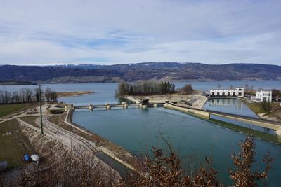
Power station and weir, Run-of-river power station in Hagneck, Switzerland.
The power station and weir in Hagneck is a run-of-river hydroelectric facility on the Aare that uses flowing water to generate electricity. The installation includes weir structures and powerhouse buildings directly integrated into the river channel.
Construction of the facility began in 1897 after the canton of Bern granted permits to local municipalities. It represents one of the region's early hydroelectric developments.
The facility is part of Hagneck's protected townscape and forms part of the region's industrial identity. The mechanical installations integrate into the river landscape and shape how the place looks to visitors.
The facility sits directly on the river and is visible from walking paths along the Aare valley. Visitors can observe the structure and its operations from public areas without restricted access concerns.
The amount of electricity generated varies with seasons, as spring snowmelt brings significantly more water to tributary streams. This visible fluctuation shows how dependent hydroelectric power is on natural cycles.
Location: Hagneck
Elevation above the sea: 430 m
Part of: list of cultural properties in Hagneck
Address: Seestrasse 23, 2575 Hagneck
Website: https://bielerseekraftwerke.ch/de/hagneck
GPS coordinates: 47.05969,7.17791
Latest update: December 14, 2025 13:07
Vinifuni Ligerz–Prêles
4.7 km
Ehemaliges Thormanngut
4.7 km
Court Ligerz
4.3 km
Festi ruin
4.6 km
Museum of viticulture on Lake Biel
4.3 km
Heidenwegturm
4.2 km
Left shore of Lake Biel
4.5 km
Katholische Kirche Täuffelen
1.8 km
Twannbachschlucht
4.8 km
Residential building for power plant employees (1914)
162 m
Reformed church
4.3 km
Ovenhouse (19th c.)
773 m
Former inn "Kreuz"
3.7 km
Priory St. Peter's Island
2.9 km
Former farmhouse (2nd quarter 19th c.)
4.1 km
Reformed church
4.2 km
Bronze age shore settlement Mörigen
3.5 km
House Gaberel
4.2 km
Rectory
3.8 km
Fraubrunnen house
4.2 km
Iron age tumulus group
4.8 km
Rectory
3.3 km
Hallstatt period burial mound group
4.5 km
Rectory and parish building (16th c.)
1.7 km
So called Rousseau-Pavillon
3.1 km
House Aarberg
4.2 km
Farmhouse (around 1880)
648 m
Farmhouse (1894/95)
734 mVisited this place? Tap the stars to rate it and share your experience / photos with the community! Try now! You can cancel it anytime.
Discover hidden gems everywhere you go!
From secret cafés to breathtaking viewpoints, skip the crowded tourist spots and find places that match your style. Our app makes it easy with voice search, smart filtering, route optimization, and insider tips from travelers worldwide. Download now for the complete mobile experience.
A unique approach to discovering new places❞
— Le Figaro
All the places worth exploring❞
— France Info
A tailor-made excursion in just a few clicks❞
— 20 Minutes