Kaiping, County-level city in Pearl River Delta, Guangdong Province, China
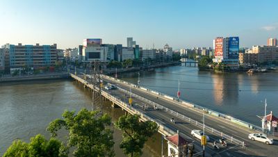
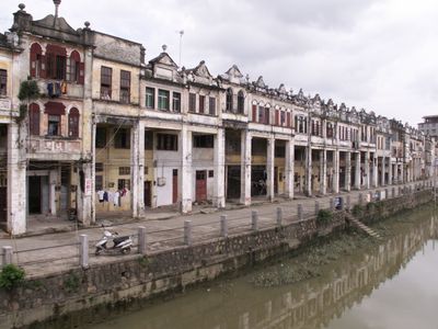
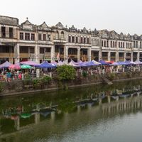
Kaiping is a county-level city in the Pearl River Delta region of Guangdong Province, spread across mountainous terrain mixed with farmland and water features. The landscape includes wetland areas and the Tanjiang River system running through it.
The region was originally part of Xin'an County administration during the Northern Song Dynasty before shifting through various administrative changes since 1649. These transitions shaped how the area developed its current form and boundaries.
The local community speaks the Sze Yup dialect, and many families maintain connections to relatives who settled in North America during earlier migration periods.
The easiest way to reach the city is by bus from Guangzhou, with the journey taking roughly two hours from central areas. Visitors should prepare for hot, humid summers and moderate winters, as the subtropical climate affects what to expect when visiting.
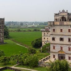
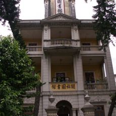
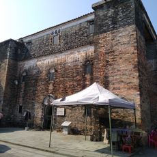
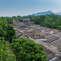
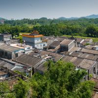
The area contains hundreds of multi-story watchtowers called Diaolou that were built during the 1920s by emigrants who returned from overseas. These structures blend Chinese and Western architectural styles in ways you don't find elsewhere in the region.
Location: Jiangmen
Capital city: 长沙街道
Elevation above the sea: 6 m
Website: http://kaiping.gov.cn
GPS coordinates: 22.37625,112.68769
Latest update: December 6, 2025 22:05
Diaolou
16.1 km
Mount Xiqiao
68 km
Zhan Garden, Zhongshan
66.6 km
Guanyin of Mount Xiqiao
68.5 km
Sun Yat-sen Memorial Library
73.4 km
Mei'an Temple
79.4 km
Former Residence of Liang Qichao (Xinhui)
40.1 km
City Walls of Zhaoqing
78.9 km
Inscriptions on precipices of Qixing Yan
81 km
Yuejiang Lou
78.1 km
Zhaoqing Xijiang Bridge
78.3 km
Guizhou Pagoda
73.5 km
Confucian Temple
39.4 km
Chen Baisha Temple
45 km
Chongxi Pagoda
77.7 km
Jinjiang Resevoir
55.4 km
Beijie Railway Station
50.5 km
Zhaoqing Yuejiang Bridge
76.8 km
Kaiping Diaolou and Villages
16.1 km
The Summit
32.3 km
Zhenhai Shuiku
25.3 km
Guan's Library
12.6 km
Jintai Temple
57.7 km
Donghu Reservoir
63.2 km
Gongcheng Shuiku
48.6 km
Yinglong Lou
7.9 km
Modidong Reservoir
87.9 km
花海泉水乐园
36.6 kmVisited this place? Tap the stars to rate it and share your experience / photos with the community! Try now! You can cancel it anytime.
Sanbu Subdistrict
Changsha (kapital sa gatos sa Republikang Popular sa Tsina, Guangdong Sheng, lat 22,38, long 112,68)
Shatang
Cangcheng (kapital sa baranggay sa Republikang Popular sa Tsina, Guangdong Sheng, lat 22,48, long 112,55)
竜勝鎮
大沙鎮
Magang (kapital sa baranggay sa Republikang Popular sa Tsina, Guangdong Sheng, lat 22,48, long 112,49)
Tangkou Township
Chikan
百合镇
Xiangang (kapital sa baranggay sa Republikang Popular sa Tsina, Guangdong Sheng, lat 22,28, long 112,53)
Jinji
Yueshan
赤水镇
水口鎮
Discover hidden gems everywhere you go!
From secret cafés to breathtaking viewpoints, skip the crowded tourist spots and find places that match your style. Our app makes it easy with voice search, smart filtering, route optimization, and insider tips from travelers worldwide. Download now for the complete mobile experience.
A unique approach to discovering new places❞
— Le Figaro
All the places worth exploring❞
— France Info
A tailor-made excursion in just a few clicks❞
— 20 Minutes