Kozelka, Nature reserve in Manětín and Nečtiny, Czech Republic.
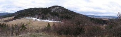
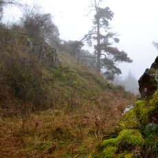
Kozelka is a protected nature reserve featuring distinctive volcanic rock formations in varied shapes across the landscape. The site showcases towers, pyramids, and flat cliff faces positioned at approximately 660 meters elevation.
The hilltop was home to one of Western Bohemia's largest Eneolithic settlements during prehistoric times. Archaeological remains from this ancient occupation can still be found at the site today.
The rock formations here have inspired local folklore about a shepherd whose cattle supposedly turned to stone as punishment. This legend remains part of how local people understand and talk about the landscape today.
The reserve is accessible via marked hiking trails that begin from a central starting point in the area. Standard hiking boots and sufficient time for exploration are recommended for a good visit.
The reserve is a major climbing destination with hundreds of established routes that attract rock climbers from across the region. The variety of climbing options at this site draws serious climbers seeking diverse challenges.
Location: Manětín
Location: Nečtiny
Inception: October 30, 1972
Elevation above the sea: 660 m
GPS coordinates: 49.99440,13.15800
Latest update: December 12, 2025 17:46
Nečtinský Špičák Castle
2.1 km
Socha svatého Floriána
2.1 km
Sochy v Nečtinách u hostince
2.1 km
Památník obětem nacismu u Nečtin
1.6 km
Památník žen z pochodu smrti
802 m
Socha svatého Vendelína
2.1 km
Socha školáka před školou v Nečtinech
1.8 km
Kaple Nejsvětejší Trojice ve Zhořci
1.9 km
Socha u cesty ke kostelu v Nečtinech
2 km
Podstavec kříže jihozápadně od Lukové
2.1 km
Plastika v Doubravici u čp. 7
654 m
Chapel of Saint Anne
654 m
Kříž u čp. 22 v Mezí
1.1 km
Wayside cross in Doubravice
761 m
Kříž ve Zhořci u silnice na Vlkošov
2 km
Kříž východně od Zhořce
1.8 km
Wayside cross west of Doubravice
508 m
Plastika u bytových domů v Nečtinách
1.9 km
Kříž v poli severozápadně od Újezdu
1.8 km
Kříž severně od Zhořce u zatáčky
2.2 km
Podstavec kříže u silnice východně od Mezí
1.2 km
Podstavec kříže v Mezí u brodu
1.3 km
Kříž u Doubravického vrchu
446 m
Kříž západně od Doubravického vrchu
421 m
Podstavec kříže severně od Mezí
1.6 km
Kříž východně od Zhořce (2)
1.8 km
Kříž v Mezí u čp. 23
1.2 km
Most silnice III/19310 přes Manětínský potok v Mezí
1.2 kmVisited this place? Tap the stars to rate it and share your experience / photos with the community! Try now! You can cancel it anytime.
Discover hidden gems everywhere you go!
From secret cafés to breathtaking viewpoints, skip the crowded tourist spots and find places that match your style. Our app makes it easy with voice search, smart filtering, route optimization, and insider tips from travelers worldwide. Download now for the complete mobile experience.
A unique approach to discovering new places❞
— Le Figaro
All the places worth exploring❞
— France Info
A tailor-made excursion in just a few clicks❞
— 20 Minutes