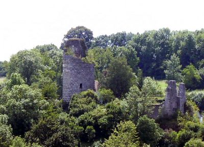
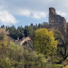
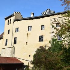
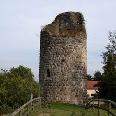
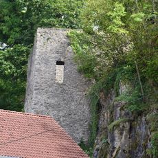
Burg Altmannstein, Medieval castle ruins in Altmannstein, Germany.
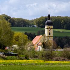
Burg Altmannstein is a castle ruin positioned on a hilltop near Altmannstein in Bavaria, Germany. The site displays remaining stone structures that offer views across the surrounding landscape.
The castle was built around 1120 as a residence for a noble family and shaped regional life for centuries. It was destroyed in the late 15th century and has remained as ruins ever since.
The ruins shape the character of Altmannstein and recall its role as a seat of an important noble family during medieval times. Visitors can observe remains that speak to a local past that defined life in the region for centuries.
Marked paths lead upward to the castle ruins, and information boards explain various features of the site. Wear sturdy shoes, as the trail can be steep and uneven in places.
The grounds contain traces of a medieval settlement that provide researchers with insight into regional life during the Middle Ages. These archaeological finds are important for understanding the local context of the time.
Location: Altmannstein
Part of: Cultural heritage D-1-7135-0206 in Altmannstein
Address: Burg-Stein-Gasse 19
GPS coordinates: 48.89612,11.65260
Latest update: December 9, 2025 20:20
Heilig-Kreuz-Kirche (Altmannstein)
188 m
Katholische Pfarrkirche Heilig Kreuz
192 m
Unsere Liebe Frau
1.4 km
Wegkapelle
461 m
Ehemalige Katharinenkirche, jetzt Wohnhaus
72 m
Ignaz Günther Museum
156 m
Wohnhaus Burg-Stein-Gasse 19 in Altmannstein
76 m
Cultural heritage D-1-7135-0206 in Altmannstein
44 m
Cultural heritage D-1-7035-0086 in Altmannstein
1.4 km
Ingolstädter Straße 3
168 m
Wohnhaus
142 m
Brauereigasthof (Altmannstein)
301 m
Wohnhaus, heute Ignaz-Günther-Museum
158 m
Wohnhaus Burg-Stein-Gasse 19 in Altmannstein
70 m
Bergfried 19 in Altmannstein
40 m
Kriegerdenkmal
163 m
Kreuzigungsgruppe Burg-Stein-Gasse 20 in Altmannstein
89 m
Pfarrhaus
1.4 km
Marter
199 m
Schermühle
611 m
Brückenfigur Heiliger Johannes Nepomuk
263 m
Ehemalige Marktbefestigung
185 m
Ehemaliges Gasthaus, jetzt Marktmuseum und Bücherei
113 m
Wohnhaus
165 m
Kalvarienberganlage
81 m
Ehemals Pfleggerichtshaus
109 m
Sogenannter Hungerturm, Teil der Burgbefestigung und Verbindung zur Marktbefestigung
40 m
Bildstock
1.3 kmVisited this place? Tap the stars to rate it and share your experience / photos with the community! Try now! You can cancel it anytime.
Discover hidden gems everywhere you go!
From secret cafés to breathtaking viewpoints, skip the crowded tourist spots and find places that match your style. Our app makes it easy with voice search, smart filtering, route optimization, and insider tips from travelers worldwide. Download now for the complete mobile experience.
A unique approach to discovering new places❞
— Le Figaro
All the places worth exploring❞
— France Info
A tailor-made excursion in just a few clicks❞
— 20 Minutes