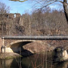
Burg Kempe, Medieval castle ruins in Mahlitzsch, Germany
Burg Kempe is a castle ruin that sits on a slate cliff directly above the Freiberger Mulde river. The surviving residential tower has three floors and measures roughly 13 by 17 meters, showing the typical scale of a medieval noble residence.
The castle first appeared in written records in 1220 as the ancestral seat of the von Mals family. The family held the property until 1298, after which it changed hands and gradually lost importance over the centuries.
The name Kempe comes from the medieval term Kemenate, which referred to a residential building for nobility. This architectural term appears throughout medieval German construction practices and still shapes how we understand such structures today.
The ruins have been privately owned since 2000 and require advance permission from the owner before visiting. Access is best reached via Zur Kempe street, from where local paths lead up to the ruins.
An underground water system ran beneath the castle, allowing defenders to resist longer during potential sieges. This engineering shows how thoughtfully medieval fortifications were planned to withstand extended attacks.
Location: Roßwein
Inception: 1300
Address: Zur Kempe
GPS coordinates: 51.08760,13.14630
Latest update: December 9, 2025 20:21
Lessing-Gymnasium
3.8 km
Schule Dresdner Straße 30c
3.7 km
Mulde road bridge Rosswein
3.8 km
Railway bridge Niederstriegis
42 m
Marienkirche
3.6 km
Villa Rößchengrundstraße 1
3.3 km
Gabelsbergerstraße 14
3.8 km
Muldebrücke Sörmitz
3.6 km
Gedenkstein für Opfer des Faschismus
2.3 km
Dr.-Zieger-Straße 3
3.6 km
Dorfkirche Niederstriegis
1 km
Brücke
2.2 km
Wohnhaus in offener Bebauung Fichtestraße 1
3.7 km
Mietshaus in geschlossener Bebauung Thielestraße 7
3.8 km
Mietshaus in geschlossener Bebauung Thielestraße 6
3.8 km
Rathaus Roßwein
3.6 km
Stadtbad Roßwein
3.4 km
Friedenseiche und Gedenkstein zum Friedensschluss 1870/71 im Deutsch-Französischen Krieg An der Schnauder
1.9 km
Kulturhaus in der Industriestraße
3.5 km
Bahnhof bestehend aus Empfangsgebäude, hölzernem Verbindungsbau und Wirtschaftsgebäude Straße des Friedens 12 (bei)
3.6 km
Pfarrhof, bestehend aus dem Pfarrhaus, dem Kantorenwohnhaus, dem Seitengebäude, einer Heiste, der Einfriedungsmauer und dem Torbogen der Einfahrt sowie dem Pfarrgarten Winkel 1
1.1 km
Straße des Friedens 20
3.8 km
Aueneiche Hermsdorf
2.2 km
Schule (heute Wohnhaus) Oberranschütz 14b
1.7 km
Mietshaus in geschlossener Bebauung Thielestraße 5
3.8 km
Wohnhaus in geschlossener Bebauung Dresdner Straße 8
3.6 km
Lutherlinde Schulweg
964 m
Villa, Garten und Einfriedung Döbelner Straße 66
3 kmVisited this place? Tap the stars to rate it and share your experience / photos with the community! Try now! You can cancel it anytime.
Discover hidden gems everywhere you go!
From secret cafés to breathtaking viewpoints, skip the crowded tourist spots and find places that match your style. Our app makes it easy with voice search, smart filtering, route optimization, and insider tips from travelers worldwide. Download now for the complete mobile experience.
A unique approach to discovering new places❞
— Le Figaro
All the places worth exploring❞
— France Info
A tailor-made excursion in just a few clicks❞
— 20 Minutes