
Bauernhof, Nachbildung eines Vierseithofs aus transferierten Teilen eines Bauernhauses und Wirtschaftsgebäuden verschiedener Provenienz; nördlich ehemaliges Wohnstallhaus, zweigeschossiger Frackdachbau mit Blockbau-Obergeschoss, erneuerter umlaufender Laube b
Location: Obertaufkirchen
Address: Hofgiebing 9
GPS coordinates: 48.23276,12.22273
Latest update: November 7, 2025 22:06
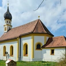
Johannes der Täufer
137 m
Zwickl (Sankt Wolfgang)
1.6 km
St. Margeret
543 m
Feldkapelle mit Kriegergedächtnisstätte
2 km
Hl. Kreuz
2 km
Stall und Stadel des Hakenhofes
1.3 km
Cultural heritage D-1-7739-0070 in Obertaufkirchen
138 m
Cultural heritage D-1-7739-0069 in Obertaufkirchen
197 m
Ehemaliger Einfirsthof
1.4 km
Scheune Hofgiebing 9 in Obertaufkirchen
26 m
Ehemaliger Stallstadel
1.3 km
Cultural heritage D-1-7739-0038 in Dorfen
2 km
Wohnstallhaus
1.4 km
Scheune Hofgiebing 9 in Obertaufkirchen
22 m
Schuppen Hofgiebing 9 in Obertaufkirchen
34 m
Kleinbauernhaus
679 m
Wohnstallstadelhaus
1.6 km
Hakenhof
1.6 km
Stadel
1.9 km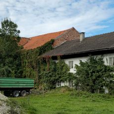
Bauernhaus
623 m
Dreiseithof
2.1 km
Bildstock
1 km
Bildstock
1.1 km
Wayside cross
1.8 km
Wayside cross
2.1 km
Wayside cross
256 m
Wayside cross
1.9 km
Wayside cross
1.1 kmReviews
Visited this place? Tap the stars to rate it and share your experience / photos with the community! Try now! You can cancel it anytime.
Discover hidden gems everywhere you go!
From secret cafés to breathtaking viewpoints, skip the crowded tourist spots and find places that match your style. Our app makes it easy with voice search, smart filtering, route optimization, and insider tips from travelers worldwide. Download now for the complete mobile experience.

A unique approach to discovering new places❞
— Le Figaro
All the places worth exploring❞
— France Info
A tailor-made excursion in just a few clicks❞
— 20 Minutes