
Stadel eines Hakenhofes
Stadel eines Hakenhofes, Zweitennig mit Flachsatteldach und Bundwerkobergeschoss, bezeichnet mit dem Jahr 1876
Location: Reichertsheim
Address: Goldbrunn 1
GPS coordinates: 48.18755,12.24330
Latest update: November 13, 2025 11:26
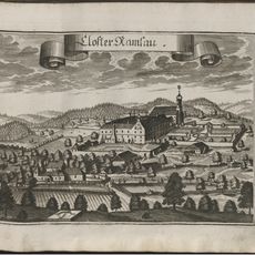
Kloster Ramsau bei Haag
1.9 km
Villa
1.5 km
Hakenhof
1.8 km
St. Maria Loreto
2 km
Einfirsthof
1.7 km
Stadel
1.6 km
Bauernhaus
1.8 km
Feldkapelle
1.7 km
Cultural heritage D-1-7839-0091 in Reichertsheim
1.9 km
Cultural heritage D-1-7839-0037 in Reichertsheim
1.3 km
Scheune Goldbrunn 1 in Reichertsheim
22 m
Cultural heritage D-1-7839-0090 in Reichertsheim
1.5 km
Cultural heritage D-1-7839-0092 in Reichertsheim
2 km
Villengarten Thambach 6 in Reichertsheim
1.5 km
Bildstock
1.6 km
Südflügel des Klosters Ramsau
1.9 km
Stadel
535 m
Gasthaus
1.4 km
Stadel
2.1 km
Wegkapelle
1.9 km
Lourdeskapelle
788 m
Stadel
1.4 km
Cultural heritage D-1-7739-0164 in Reichertsheim
2.1 km
Scheune Guggenstätt 1 in Reichertsheim
1.8 km
Lourdeskapelle Lorettostraße 16 in Reichertsheim
2 km
Wayside cross
2 km
Wayside cross
1.9 km
Wayside cross
1.4 kmReviews
Visited this place? Tap the stars to rate it and share your experience / photos with the community! Try now! You can cancel it anytime.
Discover hidden gems everywhere you go!
From secret cafés to breathtaking viewpoints, skip the crowded tourist spots and find places that match your style. Our app makes it easy with voice search, smart filtering, route optimization, and insider tips from travelers worldwide. Download now for the complete mobile experience.

A unique approach to discovering new places❞
— Le Figaro
All the places worth exploring❞
— France Info
A tailor-made excursion in just a few clicks❞
— 20 Minutes