
Brücke, einbogiger Quaderbau über den Bach, wohl frühes 19. Jahrhundert
Location: Sachsen bei Ansbach
Address: Im Tal; Raiffeisenstraße
GPS coordinates: 49.28458,10.66463
Latest update: March 10, 2025 07:04

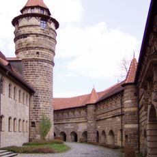
Lichtenau Fortress
1.8 km
Dreieinigkeitskirche
1.8 km
St. Johannes
1.8 km
Rutzendorfer Mühle
581 m
Pfarrhaus Lichtenau (Mittelfranken)
1.8 km
Wohnhaus
1.8 km
Wohnhaus
1.8 km
Wohngebäude
1.7 km
Alberndorf 6
2.1 km
Wohnhaus
1.8 km
Ehemaliges Brauhaus
1.7 km
Oberes südliches Tor
1.8 km
Zugehörig Scheune
1.8 km
Wohnhaus
1.8 km
Wohngebäude
1.9 km
Brauerei, ehemals auch Gastwirtschaft, Wohngebäude
1.8 km
Ehemaliges Forsthaus
1.7 km
Ehemaliges Schmiedeanwesen
1.8 km
Ehemaliges Gericht
1.8 km
Wohnhaus
1.8 km
Wohnhaus
1.8 km
Wohnhaus
1.8 km
Gasthaus
1.7 km
Unteres nördliches Tor
1.7 km
Wohnhaus
1.8 km
Wohnhaus
1.7 km
Silberbachstraße 11
2 km
Raiffeisenstraße 6
216 mReviews
Visited this place? Tap the stars to rate it and share your experience / photos with the community! Try now! You can cancel it anytime.
Discover hidden gems everywhere you go!
From secret cafés to breathtaking viewpoints, skip the crowded tourist spots and find places that match your style. Our app makes it easy with voice search, smart filtering, route optimization, and insider tips from travelers worldwide. Download now for the complete mobile experience.

A unique approach to discovering new places❞
— Le Figaro
All the places worth exploring❞
— France Info
A tailor-made excursion in just a few clicks❞
— 20 Minutes