
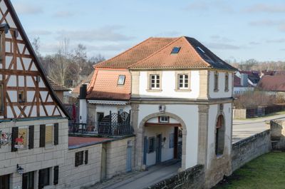
Unteres nördliches Tor, zweigeschossiges Mansarddachbau mit Tordurchfahrt unter Walmdach, bezeichnet „1763“
Location: Lichtenau
Address: Von-Heydeck-Straße 2
GPS coordinates: 49.27890,10.68585
Latest update: March 8, 2025 01:04
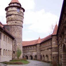
Lichtenau Fortress
104 m
Dreieinigkeitskirche
162 m
St. Johannes
456 m
Rutzendorfer Mühle
2.1 km
Pfarrhaus Lichtenau (Mittelfranken)
165 m
Wohnhaus
211 m
Wohnhaus
230 m
Wohngebäude
166 m
Wohnhaus
189 m
Mühlweg 4 (Immeldorf)
2.7 km
Ehemaliges Brauhaus
113 m
Oberes südliches Tor
237 m
Zugehörig Scheune
193 m
Wohnhaus
200 m
Wohngebäude
217 m
Brauerei, ehemals auch Gastwirtschaft, Wohngebäude
241 m
Ehemaliges Forsthaus
222 m
Ehemaliges Schmiedeanwesen
192 m
Ehemaliges Gericht
183 m
Wohnhaus
205 m
Wohnhaus
211 m
Wohnhaus
144 m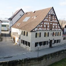
Gasthaus
20 m
Wohnstallhaus
1.6 km
Wohnhaus
139 m
Wohnhaus
126 m
Brücke (Volkersdorf)
1.7 km
Raiffeisenstraße 6
1.5 kmReviews
Visited this place? Tap the stars to rate it and share your experience / photos with the community! Try now! You can cancel it anytime.
Discover hidden gems everywhere you go!
From secret cafés to breathtaking viewpoints, skip the crowded tourist spots and find places that match your style. Our app makes it easy with voice search, smart filtering, route optimization, and insider tips from travelers worldwide. Download now for the complete mobile experience.

A unique approach to discovering new places❞
— Le Figaro
All the places worth exploring❞
— France Info
A tailor-made excursion in just a few clicks❞
— 20 Minutes