Enable Location

We need your location to show you interesting places around you

Discover nearby places

Find interesting locations and hidden gems around you

Precise directions

Get accurate directions and distances to places

Your location is never shared with other users. It's only used when you tap the location button.

Polder de la Moder

Log in to your account

Start exploring — it's free

Trusted by 62,830 travelers worldwide

Continue with Google
Continue with Apple
or

We will send you a code to connect

By continuing, you accept our Terms and Conditions and our Privacy Policy

Check your inbox

We've sent a pincode in your inbox. Please enter the code below.

Polder de la Moder

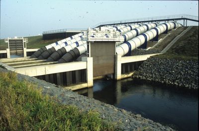
Polder de la Moder, Rückhalteraum zum Schutz vor Hochwasser am Oberrhein

Polder de la Moder is a retention basin located in Fort-Louis and Neuhaeusel that occupies the former delta of the Moder river. It can hold up to 5.6 million cubic meters of water and uses a system of dikes and channels to direct flow during flooding events.

The basin began operation in 1992, making it one of France's earliest retention structures of this type. It was built specifically to manage flooding from the Moder river and has served as a key component in the Rhine region's flood control strategy ever since.

The site is normally quiet and open, but becomes a large shallow water zone when the basin is deliberately filled for exercises. During these tests, the area is closed to visitors as staff from Voies Navigables de France checks all systems and procedures.

The basin is deliberately filled on a regular schedule to simulate flooding events and train emergency response teams. These practice runs let managers prepare realistically for actual flood situations and ensure the safety of nearby residents.

The community of curious travelers

AroundUs brings together thousands of curated places, local tips, and hidden gems, enriched daily by 60,000 contributors worldwide.

Start exploring
GPS coordinates
48.80443,8.07959
Latest update
February 9, 2026 07:45
« Polder de la Moder - Rückhalteraum zum Schutz vor Hochwasser am Oberrhein » is provided by Around Us (aroundus.com). Images and texts are derived from Wikimedia project under a Creative Commons license. You are allowed to copy, distribute, and modify copies of this page, under the conditions set by the license, as long as this note is clearly visible.

Discover hidden gems everywhere you go!

From secret cafés to breathtaking viewpoints, skip the crowded tourist spots and find places that match your style. Our app makes it easy with voice search, smart filtering, route optimization, and insider tips from travelers worldwide. Download now for the complete mobile experience.

Around Us App Screenshot

A unique approach to discovering new places

Le Figaro

All the places worth exploring

France Info

A tailor-made excursion in just a few clicks

20 Minutes

Around Us
Travel Guide & Maps
Download

Send to your phone

QR Code
1

Open the camera app on your mobile.

2

Point at the QR code with your camera. A notification will appear.

3

Tap the notification to open the link.