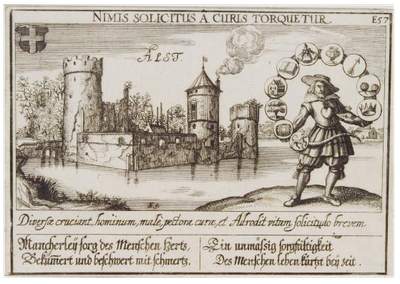
Kasteel Aalst, Medieval castle in Zaltbommel, Netherlands
Kasteel Aalst was a medieval castle in Zaltbommel featuring thick stone walls and defensive structures typical of Dutch fortifications from that era. The fortress had a square layout and was surrounded by a water-filled moat for protection.
The castle was first documented in 870 and built under the direction of Boudewijn II, Lord of Heusden, who also established fortifications in Brakel and Poederoijen. The last visible structures were demolished in 1875, marking the end of the site's physical presence.
The castle represents the architectural preferences of Dutch nobility, reflecting the era when wealthy merchants transformed their residences into symbols of power.
The original site is located in central Zaltbommel and is easily walkable, though a primary school now occupies the former grounds. Historical drawings and maps provide a good sense of what the fortress once looked like if you want to learn more before visiting.
Historical drawings preserve precise details of the fortress even though no physical structures remain visible, allowing visitors to understand its original layout and design. These visual records are a rare resource for understanding a completely demolished medieval stronghold.
Location: Zaltbommel
GPS coordinates: 51.78354,5.13077
Latest update: December 14, 2025 17:43
Hervormde kerk van Veen
1.7 km
Hervormde Kerk
2.6 km
Poldermolen
2.1 km
Maria en Sint-Antoniuskerk
362 m
Reformed church
2.6 km
De Hoop
1.8 km
Kerk van de Gereformeerde Gemeenten
441 m
De Hoop
2.7 km
Hersteld Hervormde kerk
2.7 km
Boerderijcomplex: kook- of bakhuis
2.1 km
Hervormde Kerk
1.7 km
Voormalige kortgevelboerderij van het Altenase dwarsdeeltype
1.8 km
Maasdijk 87, Aalst
600 m
Boerderij. Op T-vormige plattegrond, waarvan het door een rieten zadeldak gedekte woonhuis. Vensters met luiken en 20-ruitsschuiframen. In de noordgevel van de stal jaartalankers
2.8 km
Boerderijcomplex
2.1 km
Maasdijk 114, Aalst
598 m
Grote Kerkstraat 10, Aalburg
2.9 km
Berenhoeksestraat 8, Aalburg
2.9 km
Maasdijk 89, Aalst
605 m
Boerderij op T-vormige plattegrond, waarvan het gepleisterde woongedeelte een verdieping en een dwars rieten schilddak draagt
634 m
De Kroon 14, Wijk en Aalburg
2.4 km
Maasdijk 77, Aalst
583 m
Kerktoren
362 m
Voormalig raadhuis
1.4 km
Boerderijcomplex: varkensschuur
2.1 km
Boerderij met dwars voor de stal gebouwd woonhuis
2.8 km
Gemaal H.C. De Jongh
841 m
Huis onder schilddak, in gele baksteen
1.6 kmVisited this place? Tap the stars to rate it and share your experience / photos with the community! Try now! You can cancel it anytime.
Discover hidden gems everywhere you go!
From secret cafés to breathtaking viewpoints, skip the crowded tourist spots and find places that match your style. Our app makes it easy with voice search, smart filtering, route optimization, and insider tips from travelers worldwide. Download now for the complete mobile experience.
A unique approach to discovering new places❞
— Le Figaro
All the places worth exploring❞
— France Info
A tailor-made excursion in just a few clicks❞
— 20 Minutes