Enable Location

We need your location to show you interesting places around you

Discover nearby places

Find interesting locations and hidden gems around you

Precise directions

Get accurate directions and distances to places

Your location is never shared with other users. It's only used when you tap the location button.

Kronverksky Canal

Log in to your account

Start exploring — it's free

Trusted by 69,097 travelers worldwide

Continue with Google
Continue with Apple
or

We will send you a code to connect

By continuing, you accept our Terms and Conditions and our Privacy Policy

Check your inbox

We've sent a pincode in your inbox. Please enter the code below.

Discussion Reviews 1 Photos
1.3k Popularity

Kronverksky Canal, Canal in Kronstadt, Russia

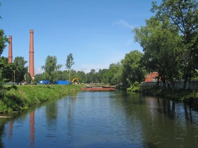
Kronverksky Canal is a waterway in Kronstadt that runs through the fortified settlement and connects different sections of the naval base. Its embankments are reinforced with stone and the waterway cuts through the geometric layout of the fortress complex.

The canal was built beginning in 1710 as part of Kronstadt's maritime development and served military and merchant vessels. Its creation was crucial for the settlement to become a key naval outpost.

The canal forms part of the Kronstadt Fortress complex and demonstrates early 18th-century Russian engineering. It allowed ships to move through the fortified settlement and connect different sections of the naval base.

You can reach the canal easily by public transport from Saint Petersburg, and the area is straightforward to explore on foot. Paved paths run along the embankments where you can observe the fortress layout and structure.

The canal was built using a distinctive technique where wooden caissons filled with stones were placed beneath the water. This early 18th-century method shows the ingenuity of its builders and remains visible in its current structure.

The community of curious travelers

AroundUs brings together thousands of curated places, local tips, and hidden gems, enriched daily by 60,000 contributors worldwide.

Start exploring
Location
Inception
1710
Part of
Kronstadt Fortress
GPS coordinates
60.00500,29.76500
Latest update
December 9, 2025 20:24
Around this place
Our Lady of Vladimir Church
Russian Federation

Our Lady of Vladimir Church

729 m
Category:Monument to City of Military Glory
Russian Federation

Category:Monument to City of Military Glory

382 m
Защитная северная плотина № 1 (Кронштадт)
Russian Federation

Защитная северная плотина № 1 (Кронштадт)

562 m
Lenin Avenue, 5
Russian Federation

Lenin Avenue, 5

634 m
Жилой дом (Кронштадт)
Russian Federation

Жилой дом (Кронштадт)

601 m
1-я северная оборонительная казарма с сухопутным манежем (Кронштадт)
Russian Federation

1-я северная оборонительная казарма с сухопутным манежем (Кронштадт)

335 m
1-я северная полубашня (Кронштадт)
Russian Federation

1-я северная полубашня (Кронштадт)

455 m
Дом церковнослужителей (Кронштадт)
Russian Federation

Дом церковнослужителей (Кронштадт)

673 m
Our Lady of Vladimir Church (Kronstadt) - fence
Russian Federation

Our Lady of Vladimir Church (Kronstadt) - fence

747 m
Служебный корпус (Кронштадт)
Russian Federation

Служебный корпус (Кронштадт)

718 m
Posadskaya Street, 5
Russian Federation

Posadskaya Street, 5

540 m
Дом по улице Карла Маркса (дом Голубева) (Кронштадт)
Russian Federation

Дом по улице Карла Маркса (дом Голубева) (Кронштадт)

703 m
Жилой дом (Кронштадт)
Russian Federation

Жилой дом (Кронштадт)

628 m
Жилой дом купца Мурашова (Кронштадт)
Russian Federation

Жилой дом купца Мурашова (Кронштадт)

620 m
Северное батардо с капониром (Кронштадт)
Russian Federation

Северное батардо с капониром (Кронштадт)

162 m
Здание штаба Кронштадтской крепости (Кронштадт)
Russian Federation

Здание штаба Кронштадтской крепости (Кронштадт)

266 m
Жилой дом (Кронштадт)
Russian Federation

Жилой дом (Кронштадт)

678 m
Сад (Кронштадт)
Russian Federation

Сад (Кронштадт)

712 m
Karali Houses
Russian Federation

Karali Houses

707 m
2-я западная оборонительная казарма (Кронштадтская) с полубашней (Кронштадт)
Russian Federation

2-я западная оборонительная казарма (Кронштадтская) с полубашней (Кронштадт)

617 m
Жилой дом (Кронштадт)
Russian Federation

Жилой дом (Кронштадт)

726 m
Владимирский собор (Кронштадт)
Russian Federation

Владимирский собор (Кронштадт)

729 m
Угловой дом (Кронштадт)
Russian Federation

Угловой дом (Кронштадт)

725 m
Hospital No36, Kronstadt
Russian Federation

Hospital No36, Kronstadt

630 m
Казарма (Кронштадт)
Russian Federation

Казарма (Кронштадт)

418 m
Казарма (Кронштадт)
Russian Federation

Казарма (Кронштадт)

451 m
Posadskaya Street, 8
Russian Federation

Posadskaya Street, 8

597 m
Часовня (Кронштадт)
Russian Federation

Часовня (Кронштадт)

715 m
Show the full map
Reviews
Share your experience

No review yet

Discussions
Start a discussion...

No discussion yet

« Kronverksky Canal - Canal in Kronstadt, Russia » is provided by Around Us (aroundus.com). Images and texts are derived from Wikimedia project under a Creative Commons license. You are allowed to copy, distribute, and modify copies of this page, under the conditions set by the license, as long as this note is clearly visible.

Discover hidden gems everywhere you go!

From secret cafés to breathtaking viewpoints, skip the crowded tourist spots and find places that match your style. Our app makes it easy with voice search, smart filtering, route optimization, and insider tips from travelers worldwide. Download now for the complete mobile experience.

Around Us App Screenshot

A unique approach to discovering new places

Le Figaro

All the places worth exploring

France Info

A tailor-made excursion in just a few clicks

20 Minutes

Around Us
Travel Guide & Maps
Download

Send to your phone

QR Code
1

Open the camera app on your mobile.

2

Point at the QR code with your camera. A notification will appear.

3

Tap the notification to open the link.