Fristad 47:1, stenkrets i Västergötland
Location: Borås Municipality
GPS coordinates: 57.80572,13.01258
Latest update: November 15, 2025 05:50
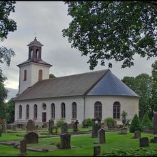
Fristad Church
1.8 km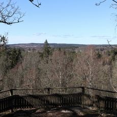
Kröklings hage
760 m
Mölarp
344 m
Fristad 63:2
1.5 km
Gingri 1:1
1.5 km
Fristad 53:2
350 m
Gingri 57:1
524 m
Gingri 2:1
1.7 km
Fristad 63:1
1.5 km
Fristad 56:1
1.4 km
Fristad 45:1
61 m
Asklanda , public beach
1.2 km
Fristad 50:1
727 m
Gingri 1:2
1.5 km
Fristad 174
1.5 km
Gingri 3:2
1.9 km
Fristad 53:1
378 m
Fristad 49:1
294 m
Fristad 160
323 m
Fristad 161
302 m
Fristad 62:1
1.7 km
Fristad 173
1.5 km
Fristad 175
1.5 km
Fristad 172
1.5 km
1Kungagraven2Flintefallet
557 m
Fristad 52:1
476 m
Gingri 3:1
1.8 km
Scenic viewpoint
688 mReviews
Visited this place? Tap the stars to rate it and share your experience / photos with the community! Try now! You can cancel it anytime.
Discover hidden gems everywhere you go!
From secret cafés to breathtaking viewpoints, skip the crowded tourist spots and find places that match your style. Our app makes it easy with voice search, smart filtering, route optimization, and insider tips from travelers worldwide. Download now for the complete mobile experience.

A unique approach to discovering new places❞
— Le Figaro
All the places worth exploring❞
— France Info
A tailor-made excursion in just a few clicks❞
— 20 Minutes