Fristad 173, stone setting in Borås Municipality, Västra Götaland County, Sweden
Location: Borås Municipality
GPS coordinates: 57.79206,13.01162
Latest update: October 31, 2025 11:11
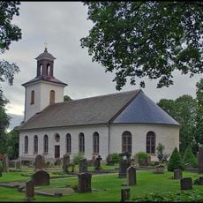
Fristad Church
3.3 km
Fristad hed
3.9 km
Kröklings hage
1.5 km
Mölarp
1.8 km
Gingri 2:1
2.7 km
Fristad 17:2
4.9 km
Altaret
3.4 km
Tärby 5:1
4.9 km
Tärby 4:2
5 km
Fristad 41:1
4.1 km
Tärby 9:2
5.1 km
Tärby 9:1
5.1 km
Rångedala 141:1
4.7 km
Tärby 2:1
5.1 km
Tärby 20:1
4.4 km
Tärby 5:2
4.9 km
Fristad 40:1
4.6 km
Tärby 4:3
5 km
Fristad 66:1
3.5 km
Rångedala 25:1
3.9 km
Tärby 4:1
5 km
Fristad 65:1
3.5 km
Tärby 3:2
5.1 km
Tärby 21:1
4.6 km
Fristad 64:1
3.6 km
Gingri 9:1
3.3 km
Brämhult 9:1
3.4 km
Tärby 28:1
4.6 kmReviews
Visited this place? Tap the stars to rate it and share your experience / photos with the community! Try now! You can cancel it anytime.
Discover hidden gems everywhere you go!
From secret cafés to breathtaking viewpoints, skip the crowded tourist spots and find places that match your style. Our app makes it easy with voice search, smart filtering, route optimization, and insider tips from travelers worldwide. Download now for the complete mobile experience.

A unique approach to discovering new places❞
— Le Figaro
All the places worth exploring❞
— France Info
A tailor-made excursion in just a few clicks❞
— 20 Minutes