Skållerud 44:1, stone setting in Mellerud Municipality, Västra Götaland County, Sweden
Location: Mellerud Municipality
GPS coordinates: 58.76789,12.44464
Latest update: November 21, 2025 22:26
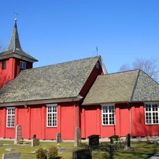
Skålleruds kyrka
1.8 km
Steinkiste auf Björkö
2.5 km
Svankila
1.8 km
Skållerud 29:1
2.4 km
Skållerud 30:1
1.8 km
Holm 56:2
2.8 km
Skållerud 64:1
1.4 km
Holm 48:1
1.7 km
Skållerud 10:1
2.5 km
Holm 114:1
2.6 km
Holm 101:2
2.9 km
Holm 47:1
1.3 km
Holm 83:1
2.9 km
Holm 101:1
2.9 km
Holm 52:2
1.2 km
Holm 101:3
2.9 km
Holm 113:1
2.4 km
Holm 113:2
2.4 km
Holm 113:3
2.4 km
Holm 39:1
2.8 km
Holm 116:1
1.5 km
Holm 51:2
612 m
Holm 56:1
2.9 km
Skållerud 45:1
243 m
Skållerud 46:1
2.9 km
Holm 52:1
1.1 km
Holm 51:1
591 m
Bramre-Karis kistor
2.5 kmReviews
Visited this place? Tap the stars to rate it and share your experience / photos with the community! Try now! You can cancel it anytime.
Discover hidden gems everywhere you go!
From secret cafés to breathtaking viewpoints, skip the crowded tourist spots and find places that match your style. Our app makes it easy with voice search, smart filtering, route optimization, and insider tips from travelers worldwide. Download now for the complete mobile experience.

A unique approach to discovering new places❞
— Le Figaro
All the places worth exploring❞
— France Info
A tailor-made excursion in just a few clicks❞
— 20 Minutes