Lerbäck 488, stone setting in Närke, Sweden
Location: Askersund Municipality
GPS coordinates: 58.91049,15.04864
Latest update: November 14, 2025 16:01
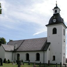
Lerbäck Church
5.2 km
Orkarebäcken
5.3 km
Lerbäcks Gästgivaritall
5.1 km
Löckna tall
2.2 km
Skyllbergs Arkivtall
4.8 km
Hammar 392:2
2.3 km
Krontallen, Dampetorp
4.3 km
Lerbäck 187:1
1.6 km
Lerbäck 487
24 m
Hammar 56:3
1.8 km
Hammar 358:1
2.7 km
Hammar 390:1
2.2 km
Sticksfallet
4.8 km
Hammar 56:2
1.8 km
Lerbäck 193:2
2.3 km
Lerbäck 193:1
2.3 km
Hammar 15:1
2.1 km
Lerbäck 324:2
4.3 km
Lerbäck 324:1
4.3 km
Hammar 49:1
1.9 km
Lerbäck 149:1
3.5 km
Lerbäcks hembygdsgård
5.1 km
Brahus
5.1 km
Hammar 49:3
1.9 km
Hammar 15:2
2.1 km
Hammar 29:1
2.7 km
Hammar 49:2
1.9 km
Hammar 392:1
2.3 kmReviews
Visited this place? Tap the stars to rate it and share your experience / photos with the community! Try now! You can cancel it anytime.
Discover hidden gems everywhere you go!
From secret cafés to breathtaking viewpoints, skip the crowded tourist spots and find places that match your style. Our app makes it easy with voice search, smart filtering, route optimization, and insider tips from travelers worldwide. Download now for the complete mobile experience.

A unique approach to discovering new places❞
— Le Figaro
All the places worth exploring❞
— France Info
A tailor-made excursion in just a few clicks❞
— 20 Minutes