Kantaberget, nature reserve in Norrbotten, Sweden
Location: Älvsbyn Municipality
Inception: December 4, 2009
GPS coordinates: 65.66626,20.31099
Latest update: November 3, 2025 18:07
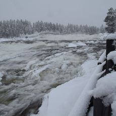
Storforsen
21.1 km
Dubblabergen
10.4 km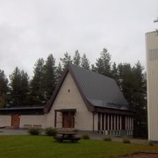
Church of Vidsel
21 km
Åkerselforsen
21.9 km
Nakteberget
6.2 km
Rävabacken
3 km
Mattisberget
16.6 km
Enstakaberget
17 km
Lill-Huvberget
20.5 km
Visttjärnliden
7.2 km
Sodokberget
17.7 km
Gårdliden
14 km
Rättselberget
20.4 km
Gaddaberget
14.8 km
Åträsket domänreservat
13.6 km
Djupträsket
17.5 km
Storberget
16.9 km
Björkselberget
15.2 km
Spjutberget-Rymmarberget
17.5 km
Storberget-Laver
12.8 km
Nuorteliden
11 km
Piteå socken 201:1
22 km
Brattforsen
14.5 km
Älvsby 805:2
19.5 km
Storforsens skogsbruks- och flottningsmuseum
20.7 km
Älvsby 805:1
19.5 km
Scenic viewpoint
20.9 km
Monument featuring aircraft, aircraft model
20.8 kmReviews
Visited this place? Tap the stars to rate it and share your experience / photos with the community! Try now! You can cancel it anytime.
Discover hidden gems everywhere you go!
From secret cafés to breathtaking viewpoints, skip the crowded tourist spots and find places that match your style. Our app makes it easy with voice search, smart filtering, route optimization, and insider tips from travelers worldwide. Download now for the complete mobile experience.

A unique approach to discovering new places❞
— Le Figaro
All the places worth exploring❞
— France Info
A tailor-made excursion in just a few clicks❞
— 20 Minutes