Rud 1:5, naturminne i Marks kommun
Location: Mark Municipality
Inception: March 28, 1963
GPS coordinates: 57.37417,12.86113
Latest update: November 19, 2025 05:19

Björkesbacka
9.6 km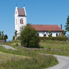
Öxabäck Church
3.8 km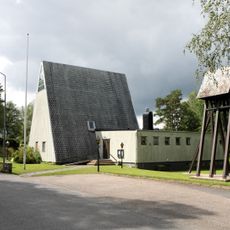
Överlida Church
3.6 km
Torestorp 51:1
9 km
Öxabäck 16:1
2.6 km
Holsljunga 89:1
9.8 km
Svänasjö Kyrkplats
9.4 km
Mjöbäck 9:2
7.2 km
Holsljunga 76:1
7.3 km
Holsljunga 86:1
9.4 km
Holsljunga 78:2
6.9 km
Öxabäck 31:1
2.7 km
Holsljunga 78:1
6.9 km
Torestorp 23:2
9.9 km
Holsljunga 76:2
7.3 km
Holsljunga 17:1
9.1 km
Öxabäck 7:2
4 km
Öxabäck 2:1
2.3 km
Överlida Industri & Hantverksmuseum
3.3 km
Torestorp 26:1
9.8 km
Torestorp 50:1
9 km
Mjöbäck 9:1
7.1 km
Öxabäck 7:1
4 km
Hönerö
9.9 km
Torestorp 37:1
9.8 km
Mjöbäck 8:1
8.1 km
Gräne Gruva
3.5 km
Christer Johansson
3.4 kmReviews
Visited this place? Tap the stars to rate it and share your experience / photos with the community! Try now! You can cancel it anytime.
Discover hidden gems everywhere you go!
From secret cafés to breathtaking viewpoints, skip the crowded tourist spots and find places that match your style. Our app makes it easy with voice search, smart filtering, route optimization, and insider tips from travelers worldwide. Download now for the complete mobile experience.

A unique approach to discovering new places❞
— Le Figaro
All the places worth exploring❞
— France Info
A tailor-made excursion in just a few clicks❞
— 20 Minutes