Yate, Market town in South Gloucestershire, England.
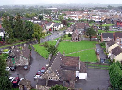
Yate is a town in the northeast part of South Gloucestershire that spreads across residential streets, retail areas and open fields. The layout includes housing estates, shopping centers and parks linked by roads and footpaths.
The settlement appears in records from the eighth century as a gateway to woodland areas. In the twentieth century the community grew from a village into a suburban town with housing estates and industrial sites.
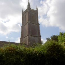
St Mary's Church stands as the central religious building of Yate, with its Norman architecture modified through the centuries and restored in 1970.
A railway station links the town to Bristol in the southwest and Birmingham in the north. Local bus routes run through the residential areas and stop at main junctions and shopping districts.
During the Second World War the local railway yard served as a depot for material transport by American forces. Residents still recall the busy years when military vehicles moved through the streets.
Location: South Gloucestershire
Shares border with: Chipping Sodbury
Website: http://yatetowncouncil.gov.uk
GPS coordinates: 51.54083,-2.41861
Latest update: December 14, 2025 17:19
Town Hall
1.8 km
Parish Church of St John the Baptist
1.7 km
Parish Church of St Mary the Virgin
424 m
Bust of Andrew Foxwell
1.7 kmThe Squire Public House
1.8 km
War Memorial and Remains of Town Cross
1.9 km
The Grapes Hotel
1.5 km
War Memorial Lych Gate
415 m
The George Hotel
1.8 kmPortcullis Hotel
1.9 kmWater Pump, 10 Feet In Front Of Number 46
1.8 km
Royal Oak Public House
1.9 km
Road to nowhere
1.4 kmRidgewood,Yate Offices Of Avon County Social Services
822 mChest Tomb, 1 Yard South Of Item 7/224
414 mGoosegreen Farmhouse
1.3 km1 and 1A, Rounceval Street
1.4 km
Chipping Sodbury Library
1.7 km
War Memorial and Grave Marker, Church of St Mary's Churchyard
396 mPinnell Chest Tomb,25 Yards To South East Of South Porch Of St Mary's Church
416 mKirkdale
1.5 kmRaggat Chest Tomb, 11 Yards South Of South West Corner Of Porch Of St Mary's Church
402 mChest Tomb 5 Yards South Of Porch Of St Mary's Church
411 m
75, Broad Street
1.8 km
2, High Street
1.5 km37, High Street
1.7 km16, High Street
1.6 km22, High Street
1.6 kmVisited this place? Tap the stars to rate it and share your experience / photos with the community! Try now! You can cancel it anytime.
Discover hidden gems everywhere you go!
From secret cafés to breathtaking viewpoints, skip the crowded tourist spots and find places that match your style. Our app makes it easy with voice search, smart filtering, route optimization, and insider tips from travelers worldwide. Download now for the complete mobile experience.
A unique approach to discovering new places❞
— Le Figaro
All the places worth exploring❞
— France Info
A tailor-made excursion in just a few clicks❞
— 20 Minutes