Enable Location

We need your location to show you interesting places around you

Discover nearby places

Find interesting locations and hidden gems around you

Precise directions

Get accurate directions and distances to places

Your location is never shared with other users. It's only used when you tap the location button.

Totton and Eling

Log in to your account

Start exploring — it's free

Trusted by 63,027 travelers worldwide

Continue with Google
Continue with Apple
or

We will send you a code to connect

By continuing, you accept our Terms and Conditions and our Privacy Policy

Check your inbox

We've sent a pincode in your inbox. Please enter the code below.

Discussion Reviews 1 Photos
13k Popularity

Totton and Eling, Civil parish near Southampton, England

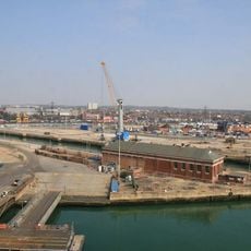
Totton and Eling is a civil parish positioned between the eastern edge of New Forest and the River Test, forming a substantial residential area with homes and local facilities. The district comprises residential streets, local shops, and green spaces that extend from the forest boundary down to the river valley.

Archaeological findings at Tatchbury Mount reveal Iron Age settlements, while ancient tools indicate human presence in the area dating back to Paleolithic times. These layers of human activity span thousands of years, demonstrating long-term occupation of the land.

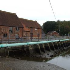
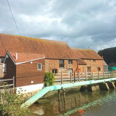
Eling Tide Mill shapes the local identity as a working mill that has served the community for centuries through water-powered grain processing. Visitors can observe how traditional milling techniques remain embedded in the daily rhythm of this waterside area.

Totton Railway Station connects the area to Southampton, London, and Bournemouth, making it easy to take day trips to larger towns. The area also has local buses and good road access for those arriving by car.

Eling Tide Mill is mentioned in the Domesday Book and remains one of Europe's rare operating tidal mills, producing flour since 1418. The fact that it still harnesses water for power makes it a living example of medieval engineering innovation.

The community of curious travelers

AroundUs brings together thousands of curated places, local tips, and hidden gems, enriched daily by 60,000 contributors worldwide.

Start exploring
Location
GPS coordinates
50.92000,-1.49000
Latest update
December 7, 2025 20:42
Around this place
SS Shieldhall
United Kingdom

SS Shieldhall

3.6 km
King George V Dry Dock
United Kingdom

King George V Dry Dock

3.6 km
New Forest Wildlife Park
United Kingdom

New Forest Wildlife Park

3.8 km
Eling Tide Mill
United Kingdom

Eling Tide Mill

1.1 km
Eling Tide Mill Experience Visitor Centre
United Kingdom

Eling Tide Mill Experience Visitor Centre

1.1 km
Church of St Boniface
United Kingdom

Church of St Boniface

3 km
Church of St Matthew
United Kingdom

Church of St Matthew

2.7 km
Colbury Christ Church
United Kingdom

Colbury Christ Church

2.9 km
Church of St Winfred
United Kingdom

Church of St Winfred

430 m
Church of St Mary
United Kingdom

Church of St Mary

1.3 km
Church of St John the Apostle
United Kingdom

Church of St John the Apostle

4.2 km
Church of the Holy Trinity
United Kingdom

Church of the Holy Trinity

2.6 km
Redbridge Bridge
United Kingdom

Redbridge Bridge

1.1 km
The Cross Keys Public House
United Kingdom

The Cross Keys Public House

190 m
No. 7 Pumping Station At King George V Dry Dock
United Kingdom

No. 7 Pumping Station At King George V Dry Dock

3.6 km
Regent Cinema
United Kingdom

Regent Cinema

3.9 km
Netley Marsh War Memorial
United Kingdom

Netley Marsh War Memorial

2.8 km
Milestone, Redbridge Road, Redbridge
United Kingdom

Milestone, Redbridge Road, Redbridge

1.8 km
The Old Rectory
United Kingdom

The Old Rectory

1.4 km
369 And 371A, Millbrook Road
United Kingdom

369 And 371A, Millbrook Road

3.4 km
Milestone, Brokenford; by No. 144 Ringwood Road
United Kingdom

Milestone, Brokenford; by No. 144 Ringwood Road

577 m
Milestone, Hunter's Inn Hill; N of jcn Deerleap lane
United Kingdom

Milestone, Hunter's Inn Hill; N of jcn Deerleap lane

2.6 km
Milestone, Sharves Hill
United Kingdom

Milestone, Sharves Hill

2.5 km
Milestone, W of jct of Crabbs Way with Ringwood Road
United Kingdom

Milestone, W of jct of Crabbs Way with Ringwood Road

2.1 km
Milestone, Rushington, jct of Spicers Hill and The Drive
United Kingdom

Milestone, Rushington, jct of Spicers Hill and The Drive

1.1 km
Milestone, Ashurst Station
United Kingdom

Milestone, Ashurst Station

4.1 km
Milestone, Tennis Centre,  Romsey Road, Nursling; opp. the Cedar School for the Physically handicapped,
United Kingdom

Milestone, Tennis Centre, Romsey Road, Nursling; opp. the Cedar School for the Physically handicapped,

3.3 km
Milestone, Romsey Road, Maybush
United Kingdom

Milestone, Romsey Road, Maybush

3.2 km
Show the full map
Reviews
Share your experience

No review yet

Discussions
Start a discussion...

No discussion yet

« Totton and Eling - Civil parish near Southampton, England » is provided by Around Us (aroundus.com). Images and texts are derived from Wikimedia project under a Creative Commons license. You are allowed to copy, distribute, and modify copies of this page, under the conditions set by the license, as long as this note is clearly visible.

Discover hidden gems everywhere you go!

From secret cafés to breathtaking viewpoints, skip the crowded tourist spots and find places that match your style. Our app makes it easy with voice search, smart filtering, route optimization, and insider tips from travelers worldwide. Download now for the complete mobile experience.

Around Us App Screenshot

A unique approach to discovering new places

Le Figaro

All the places worth exploring

France Info

A tailor-made excursion in just a few clicks

20 Minutes

Around Us
Travel Guide & Maps
Download

Send to your phone

QR Code
1

Open the camera app on your mobile.

2

Point at the QR code with your camera. A notification will appear.

3

Tap the notification to open the link.