Happisburgh, Historic coastal village in North Norfolk, England
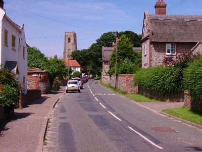
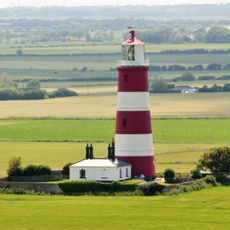
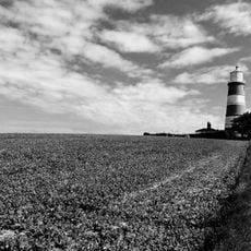
Happisburgh is a village along the northeastern Norfolk coast featuring a distinctive white lighthouse marked with three red bands. The lighthouse and the medieval church form the main landmarks that visitors see walking through this quiet settlement.
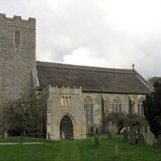
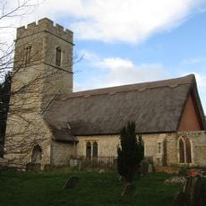
This village developed in the Middle Ages when the church was first built, then substantially rebuilt in the 15th century. Archaeological finds from 2010 revealed that humans inhabited this area roughly 800,000 years ago, making it the oldest known settlement site in Britain.
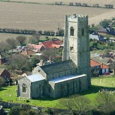
St. Mary's Church shapes the village center with its distinctive tower and has guided seafarers for centuries. The building anchors community life and remains a visual landmark that travelers notice from afar.
The village car park provides level beach access via an earth ramp and includes year-round toilet facilities for visitors. The walking paths to the shore and through the village are straightforward and suit most visitors.
The lighthouse dates to 1790 and operates as Britain's only independently maintained light, kept going by the community's voluntary support rather than government funding. This arrangement makes it stand apart from other British coastal lights.
Location: North Norfolk
Website: http://happisburgh.org.uk
GPS coordinates: 52.82420,1.53090
Latest update: December 6, 2025 22:05
Happisburgh footprints
301 m
Happisburgh Lighthouse
740 m
Bromholm Priory
3.9 km
East Ruston Old Vicarage
2.6 km
St Andrew's Church, Hempstead
3.5 km
St Mary's Church, East Ruston
2.8 km
Church of Holy Trinity
5.1 km
The Museum of the Broads
6.4 km
Church of St Peter
3.4 km
Church of St Mary
122 m
Church of St Mary the Virgin
5.9 km
Church of St Margaret
6.5 km
Church of St Peter
4.4 km
Church of All Saints
4.7 km
Church of All Saints
2.8 km
Church of All Saints
2.1 km
The Hill House
118 m
East Ruston War Memorial
2.8 km
Barn at Church Farm
3.2 km
Ingham War Memorial Cross
5.1 km
Barn At Dale Farm
6.1 km
St Anne's Including Outhouse
102 m
Stable Block To North Of Drive To St Mary's
81 m
Dale Farmhouse
6.2 km
Thrums
67 m
Bromholm Priory: north gatehouse and attached precinct wall
4 km
St Mary's Including 2 Summerhouses
196 m
Milestone, 20yds W of entrance to The Hall
6.1 kmVisited this place? Tap the stars to rate it and share your experience / photos with the community! Try now! You can cancel it anytime.
Discover hidden gems everywhere you go!
From secret cafés to breathtaking viewpoints, skip the crowded tourist spots and find places that match your style. Our app makes it easy with voice search, smart filtering, route optimization, and insider tips from travelers worldwide. Download now for the complete mobile experience.
A unique approach to discovering new places❞
— Le Figaro
All the places worth exploring❞
— France Info
A tailor-made excursion in just a few clicks❞
— 20 Minutes