Wallingford Castle, Medieval castle in Wallingford, England
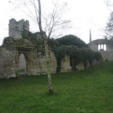
Wallingford Castle is a Norman fortress near the River Thames in the town of Wallingford, England. The original structure featured a stone shell keep with walls and a surrounding curtain wall that enclosed the main courtyard.
A Norman commander built the fortress shortly after 1066 to control the Thames Valley and establish Norman authority in the region. The castle became one of the strongest royal strongholds and remained strategically important through the medieval period.
The castle served as a royal residence and holding place for important prisoners from noble families. Visitors can sense how central this location was to medieval power structures in the Thames Valley.
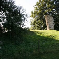
The ruins are accessible through a garden setting that incorporates parts of the original Norman earthwork defenses. Visitors should expect uneven ground and partially exposed foundations that help reveal the layout of different sections.
A medieval commander once operated a notorious prison within the walls whose inmates' cries reportedly reached the surrounding town. This grim facility gave the place a dark reputation that persisted in local stories.
Location: Wallingford
Inception: 1067
Architectural style: Norman architecture
GPS coordinates: 51.60320,-1.12172
Latest update: December 22, 2025 17:45
South Cemetery Chapel
239 m
Town Arms Public House
233 m
Monument to Thomas Bennett in All Hallows Churchyard
207 m
Number 100 And Attached Gateway
236 m
Remains Of St Nicholas's College
146 m
St Nicholas And Attached Railings
228 mK6 Telephone Kiosk By The Bridge
256 m
8 and 8B, Castle Street
266 m7-11, High Street
252 m89, High Street
237 mStrafford House
233 m
88, High Street
247 mWharf House
230 m
Fragment Of Castle Wall At Su 6096 8978
61 m
92 And 93, High Street
236 mChest Tomb To Button Family In All Hallows Churchyard
207 m
Calleva House
257 mBear Lane House
210 mRailing Approximately 7 Metres South Of St Nicholas
238 m
Stoney's Restaurant
259 mFriend's Meeting House
248 m
17,18 and 19, High Street
266 m
Thames House
255 m
St Michael's House
233 mWall Approxmately 20 Metres West Of Bear Lane House
208 mGatepier At Su 6080 8985, Approximately 90 Metres East Of Park Farmhouse
167 m13,14 And 15, High Street
264 mWallingford Stamp Centre Ye Olde Bakery
262 mVisited this place? Tap the stars to rate it and share your experience / photos with the community! Try now! You can cancel it anytime.
Discover hidden gems everywhere you go!
From secret cafés to breathtaking viewpoints, skip the crowded tourist spots and find places that match your style. Our app makes it easy with voice search, smart filtering, route optimization, and insider tips from travelers worldwide. Download now for the complete mobile experience.
A unique approach to discovering new places❞
— Le Figaro
All the places worth exploring❞
— France Info
A tailor-made excursion in just a few clicks❞
— 20 Minutes