Chest opened
+${chestReward.xp} XP
Explorer
NOUVEAU ×${chestReward.collectible.quantity}
tapez pour fermer
Chest locked

Open chests in the app

Around Us is built for your phone — chests unlock when you walk, explore and capture nearby places.

Enable Location

We need your location to show you interesting places around you

Discover nearby places

Find interesting locations and hidden gems around you

Precise directions

Get accurate directions and distances to places

Your location is never shared with other users. It's only used when you tap the location button.

River Nidd

Log in to your account

Start exploring — it's free

Trusted by 72,877 travelers worldwide

Continue with Google
Continue with Apple
or

We will send you a code to connect

By continuing, you accept our Terms and Conditions and our Privacy Policy

Check your inbox

We've sent a pincode in your inbox. Please enter the code below.

River Nidd
Discussion Reviews 1 Photos
11.2k Popularity

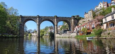
River Nidd, River in North Yorkshire, England.

The River Nidd flows from high moorland through North Yorkshire, passing through valleys and several settlements before merging with the River Ouse. The water is managed by reservoirs along its path and feeds the surrounding countryside.

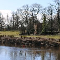
The river powered mills and supported local industries for centuries until major reservoirs were built in the early 1900s to supply water to cities. These dams transformed the landscape and changed how the water flows through the valley.

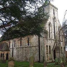
The river is deeply tied to fishing traditions and supports communities that have depended on it for generations. Visitors today experience this heritage through angling spots and the villages that line its banks.

This watercourse is reachable by several walking paths, with the Nidderdale Way being the main long-distance route through the valley. The best time to explore is from spring through autumn, when weather is more stable and paths are easier to walk.

At certain points the water sinks underground into limestone caves and reappears downstream. This natural disappearing act is most noticeable after heavy rainfall, making the river behave in ways that seem almost mysterious.

The community of curious travelers

AroundUs brings together thousands of curated places, local tips, and hidden gems, enriched daily by 60,000 contributors worldwide.

Start exploring
Location
GPS coordinates
54.01417,-1.21889
Latest update
December 8, 2025 13:42
Around this place
Church of St Mary
United Kingdom

Church of St Mary

147 m
United Kingdom

Statue of Shepherd with Pipe and Pedestal Approximately 20 Metres South West of the Priory

114 m
United Kingdom

Statue of A Sailors Moll and Pedestal Approximately 20 Metres South of the Priory

90 m
United Kingdom

Statue of Minerva and Pedestal Approximately 40 Metres East of the Priory

85 m
United Kingdom

Statue of Girl with Birds Nest and Pedestal Approximately 30 Metres East of the Priory

91 m
United Kingdom

Statue of Mars and Pedestal Approximately 40 Metres South of the Priory

88 m
United Kingdom

Statue of Fame and Pedestal Approximately 35 Metres North East of the Priory

134 m
United Kingdom

Statue of the Haymaker and Pedestal Approximately 35 Metres North of the Priory

140 m
Water Tower
United Kingdom

Water Tower

94 m
United Kingdom

Statue of the Bucaneer and Pedestal Approximately 20 Metres South of the Priory

101 m
Cross Stump
United Kingdom

Cross Stump

585 m
United Kingdom

The Laundry House

788 m
United Kingdom

Ha Ha To West And South Of Hall

699 m
United Kingdom

The Priory

123 m
United Kingdom

The Brew House

773 m
United Kingdom

Plum Tree Cottage

598 m
United Kingdom

Hatch End

584 m
United Kingdom

Avenue Cottage

205 m
United Kingdom

Sundial Approximately 12 Metres South Of The Priory

101 m
United Kingdom

Church House And Wall To East

643 m
United Kingdom

West Side Farmhouse

661 m
United Kingdom

Mallards

546 m
United Kingdom

The Alice Hawthorne

435 m
United Kingdom

Pump House Approximately 250 Metres To West North West Of Hall

755 m
United Kingdom

White Swan House And Railings To South

383 m
United Kingdom

Priory Cottage

181 m
United Kingdom

Gate Piers To West And Garden Wall To South West And North Of The Priory

133 m
United Kingdom

Summer Pavilion Approximately 45 Metres South East Of The Priory

69 m
Show the full map
Reviews
Share your experience

No review yet

Discussions
Start a discussion...

No discussion yet

« River Nidd - River in North Yorkshire, England » is provided by Around Us (aroundus.com). Images and texts are derived from Wikimedia project under a Creative Commons license. You are allowed to copy, distribute, and modify copies of this page, under the conditions set by the license, as long as this note is clearly visible.

Discover hidden gems everywhere you go!

From secret cafés to breathtaking viewpoints, skip the crowded tourist spots and find places that match your style. Our app makes it easy with voice search, smart filtering, route optimization, and insider tips from travelers worldwide. Download now for the complete mobile experience.

Around Us App Screenshot

A unique approach to discovering new places

Le Figaro

All the places worth exploring

France Info

A tailor-made excursion in just a few clicks

20 Minutes

Around Us
Travel Guide & Maps
Download

Send to your phone

QR Code
1

Open the camera app on your mobile.

2

Point at the QR code with your camera. A notification will appear.

3

Tap the notification to open the link.