Chest opened
+${chestReward.xp} XP
Explorer
NOUVEAU ×${chestReward.collectible.quantity}
tapez pour fermer
Chest locked

Open chests in the app

Around Us is built for your phone — chests unlock when you walk, explore and capture nearby places.

Enable Location

We need your location to show you interesting places around you

Discover nearby places

Find interesting locations and hidden gems around you

Precise directions

Get accurate directions and distances to places

Your location is never shared with other users. It's only used when you tap the location button.

River Douglas

Log in to your account

Start exploring — it's free

Trusted by 72,885 travelers worldwide

Continue with Google
Continue with Apple
or

We will send you a code to connect

By continuing, you accept our Terms and Conditions and our Privacy Policy

Check your inbox

We've sent a pincode in your inbox. Please enter the code below.

River Douglas
Discussion Reviews 1 Photos
9.7k Popularity

River Douglas, River system in Lancashire and Greater Manchester, England

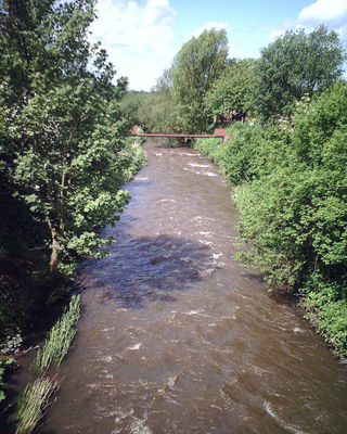
The River Douglas is a river system that flows roughly 35 miles from Winter Hill through Lancashire and Greater Manchester, eventually meeting the River Ribble at Tarleton. The waterway passes through varied terrain and settlements, creating a significant water corridor across the region.

The river formed the basis of the Douglas Navigation scheme built between 1738 and 1742, which enabled coal transport from Wigan to coastal markets. This waterway became less important after the late 18th century, though its infrastructure remains part of the area's industrial heritage.

The river takes its name from ancient Brittonic words meaning dark stream, preserving an old linguistic layer in the region. Local names like this often reveal how early inhabitants described the natural world around them.

Multiple access points and footpaths line the river banks, making it suitable for walking, cycling, and wildlife watching. The waterway is easy to explore on foot or by bike, with several starting points allowing flexible route planning.

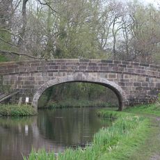
An aqueduct from the 1790s allows the Leeds and Liverpool Canal to pass above the water at Worthington Lakes, showcasing engineering skill from the industrial age. This clever solution let two transport routes share the same space without interfering with each other.

The community of curious travelers

AroundUs brings together thousands of curated places, local tips, and hidden gems, enriched daily by 60,000 contributors worldwide.

Start exploring
Location
GPS coordinates
53.73470,-2.85507
Latest update
December 10, 2025 15:57
Around this place
Carr House
United Kingdom

Carr House

5.9 km
St Michael's Church, Kirkham
United Kingdom

St Michael's Church, Kirkham

5.6 km
St John the Evangelist's Church, Kirkham
United Kingdom

St John the Evangelist's Church, Kirkham

5.6 km
Becconsall Old Church
United Kingdom

Becconsall Old Church

3.9 km
All Saints Church, Becconsall
United Kingdom

All Saints Church, Becconsall

3.7 km
St John the Evangelist's Church, Clifton
United Kingdom

St John the Evangelist's Church, Clifton

5.3 km
St Nicholas' Church, Wrea Green
United Kingdom

St Nicholas' Church, Wrea Green

6.2 km
Church of the Holy Trinity
United Kingdom

Church of the Holy Trinity

2.3 km
Salwick Hall Bridge (Number 24)
United Kingdom

Salwick Hall Bridge (Number 24)

6.2 km
Church of St Michael
United Kingdom

Church of St Michael

5.2 km
Kirkham United Reformed Church
United Kingdom

Kirkham United Reformed Church

5.5 km
St Andrew's Church, Longton
United Kingdom

St Andrew's Church, Longton

4.9 km
St Paul's Church, Warton
United Kingdom

St Paul's Church, Warton

3.1 km
Hesketh Bank War Memorial
United Kingdom

Hesketh Bank War Memorial

3.7 km
The Windmill Tavern
United Kingdom

The Windmill Tavern

5.2 km
Tomb of William Birley and others in churchyard circa 50 metres south east of the porch of the Church of St Michael
United Kingdom

Tomb of William Birley and others in churchyard circa 50 metres south east of the porch of the Church of St Michael

5.6 km
Wilson's Bridge Number 25
United Kingdom

Wilson's Bridge Number 25

6.2 km
Churchyard Wall And Gateway South Of The Church Of St John The Evangelist
United Kingdom

Churchyard Wall And Gateway South Of The Church Of St John The Evangelist

5.5 km
Hillside And Attached Wings
United Kingdom

Hillside And Attached Wings

5.3 km
Milestone
United Kingdom

Milestone

5.2 km
76, Preston Old Road
United Kingdom

76, Preston Old Road

2.1 km
Hall Cross Farmhouse
United Kingdom

Hall Cross Farmhouse

3.6 km
Milestone, Newton with Scales
United Kingdom

Milestone, Newton with Scales

4.5 km
Milestone, Clifton; W end village
United Kingdom

Milestone, Clifton; W end village

4.4 km
Milestone, Preston Road, Dowbridge; opp. Glebe Lane, by No. 73
United Kingdom

Milestone, Preston Road, Dowbridge; opp. Glebe Lane, by No. 73

5 km
Milestone, Grove Ave jcn
United Kingdom

Milestone, Grove Ave jcn

4.4 km
Milestone, Ribby
United Kingdom

Milestone, Ribby

6.2 km
Milestone, W of Savick Bridge
United Kingdom

Milestone, W of Savick Bridge

4.8 km
Show the full map
Reviews
Share your experience

No review yet

Discussions
Start a discussion...

No discussion yet

« River Douglas - River system in Lancashire and Greater Manchester, England » is provided by Around Us (aroundus.com). Images and texts are derived from Wikimedia project under a Creative Commons license. You are allowed to copy, distribute, and modify copies of this page, under the conditions set by the license, as long as this note is clearly visible.

Discover hidden gems everywhere you go!

From secret cafés to breathtaking viewpoints, skip the crowded tourist spots and find places that match your style. Our app makes it easy with voice search, smart filtering, route optimization, and insider tips from travelers worldwide. Download now for the complete mobile experience.

Around Us App Screenshot

A unique approach to discovering new places

Le Figaro

All the places worth exploring

France Info

A tailor-made excursion in just a few clicks

20 Minutes

Around Us
Travel Guide & Maps
Download

Send to your phone

QR Code
1

Open the camera app on your mobile.

2

Point at the QR code with your camera. A notification will appear.

3

Tap the notification to open the link.