Old Rectory

Log in to your account

AroundUs is a community-driven map of interesting places, built by curious explorers like you. It grows with every review, story, and photo you share.
Connect to save your favorite spots, contribute locations, and create personalized routes.
Continue with Google
Continue with Apple
Continue with X
Continue with Facebook
Continue with email
By continuing, you accept our Terms and Conditions and our Privacy Policy
Create an account

Old Rectory

Add to collection
Map
Suggest a change
Share

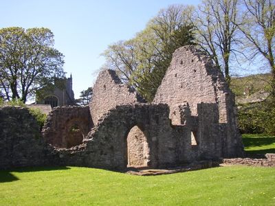
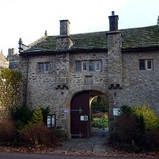
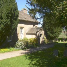
Old Rectory, Medieval ruins in Warton, England

The Old Rectory in Warton is a ruin built from limestone and sandstone with walls that still stand to a significant height. The preserved structure shows traces of a great hall, service areas, and upper-floor chambers where the medieval household operated.

This structure was built in the early 14th century as a residence for the parish priest of St Oswald's Church. It was commissioned by the sons of a local nobleman named Lord Thweng and has stood in this landscape for roughly 700 years.

The site served as both a residence and a place where local courts met to settle disputes and conduct administrative business. This shows how religious officials held power over both spiritual and everyday matters in medieval villages.

The ruins are open year-round to visitors without any entrance fee and are maintained by English Heritage. The site sits near walking paths and is easy to reach on foot, though there is little shelter or shade once you arrive.

The gables of this ruin still reach their original medieval height, which is rare among structures this old and gives visitors a clear picture of the building's original shape. Few medieval ruins retain this level of architectural completeness in their upper sections.

GPS coordinates: 54.14425,-2.76816

Latest update: December 14, 2025 11:41

Photos
Around this place
Carnforth MPD
United Kingdom

Carnforth MPD

1.5 km
Leighton Hall, Lancashire
United Kingdom

Leighton Hall, Lancashire

2.1 km
St Oswald's Church
United Kingdom

St Oswald's Church

90 m
St Mary's Church, Yealand Conyers
United Kingdom

St Mary's Church, Yealand Conyers

1.9 km
St John the Evangelist's Church, Yealand Conyers
United Kingdom

St John the Evangelist's Church, Yealand Conyers

2.6 km
Carnforth War Memorial
United Kingdom

Carnforth War Memorial

1.7 km
St Oswald Vicarage
United Kingdom

St Oswald Vicarage

22 m
Christ Church
United Kingdom

Christ Church

1.8 km
Roxy Cinema
United Kingdom

Roxy Cinema

1.7 km
Shovel Inn
United Kingdom

Shovel Inn

1.8 km
Lancaster Canal Borwick Hall Bridge (Number 135)
United Kingdom

Lancaster Canal Borwick Hall Bridge (Number 135)

2.6 km
Lancaster Canal Tewitfield Old Turnpike Bridge (Number 138)
United Kingdom

Lancaster Canal Tewitfield Old Turnpike Bridge (Number 138)

2.4 km
Lancaster Canal Kellet Lane Bridge (Number 130)
United Kingdom

Lancaster Canal Kellet Lane Bridge (Number 130)

2.3 km
Dale House
United Kingdom

Dale House

2 km
Lancaster Canal Hodgson's Bridge (Number 129)
United Kingdom

Lancaster Canal Hodgson's Bridge (Number 129)

1.8 km
Lancaster Canal Tewitfield Locks
United Kingdom

Lancaster Canal Tewitfield Locks

2.5 km
Milestone 150 Metres South Of The Junction With Alexandra Road At Ngr Sd 495 701
United Kingdom

Milestone 150 Metres South Of The Junction With Alexandra Road At Ngr Sd 495 701

2.2 km
Carnforth: The Coaling Plant
United Kingdom

Carnforth: The Coaling Plant

1.6 km
Lancaster Canal Taylor's Bridge (Number 137)
United Kingdom

Lancaster Canal Taylor's Bridge (Number 137)

2.7 km
Lancaster Canal Sanders Bridge (Number 136)
United Kingdom

Lancaster Canal Sanders Bridge (Number 136)

2.6 km
Former Signal Box, North End Of Platform At Carnforth Station, Ngr Sd 49692 70834
United Kingdom

Former Signal Box, North End Of Platform At Carnforth Station, Ngr Sd 49692 70834

1.5 km
Borwick Hall Gatehouse
United Kingdom

Borwick Hall Gatehouse

2.7 km
Carnforth Station Junction Signal Box
United Kingdom

Carnforth Station Junction Signal Box

1.4 km
Milestone On West Side, South Of Junction With Borwick Lane At Ngr Sd 513 728
United Kingdom

Milestone On West Side, South Of Junction With Borwick Lane At Ngr Sd 513 728

1.5 km
Milestone On South Bank Of Lancaster Canal, 130 Metres East Of Tewitfield Old Turnpike Bridge At Ngr Sd 522 733
United Kingdom

Milestone On South Bank Of Lancaster Canal, 130 Metres East Of Tewitfield Old Turnpike Bridge At Ngr Sd 522 733

2.5 km
Quaker Meeting House
United Kingdom

Quaker Meeting House

2.2 km
Warton War Memorial, Lancashire
United Kingdom

Warton War Memorial, Lancashire

98 m
Milestone, Burton Road, Millhead, on bridge over River Keer, just before island for Truckhaven
United Kingdom

Milestone, Burton Road, Millhead, on bridge over River Keer, just before island for Truckhaven

1 km
Show the full map
Reviews

Visited this place? Tap the stars to rate it and share your experience / photos with the community! Try now! You can cancel it anytime.

« Old Rectory - Medieval ruins in Warton, England » is provided by Around Us (aroundus.com). Images and texts are derived from Wikimedia project under a Creative Commons license. You are allowed to copy, distribute, and modify copies of this page, under the conditions set by the license, as long as this note is clearly visible.

Discover hidden gems everywhere you go!

From secret cafés to breathtaking viewpoints, skip the crowded tourist spots and find places that match your style. Our app makes it easy with voice search, smart filtering, route optimization, and insider tips from travelers worldwide. Download now for the complete mobile experience.

Around Us App Screenshot

A unique approach to discovering new places

Le Figaro

All the places worth exploring

France Info

A tailor-made excursion in just a few clicks

20 Minutes