Enable Location

We need your location to show you interesting places around you

Discover nearby places

Find interesting locations and hidden gems around you

Precise directions

Get accurate directions and distances to places

Your location is never shared with other users. It's only used when you tap the location button.

Draycote Water

Log in to your account

Start exploring — it's free

Trusted by 61,471 travelers worldwide

Continue with Google
Continue with Apple
or

We will send you a code to connect

By continuing, you accept our Terms and Conditions and our Privacy Policy

Check your inbox

We've sent a pincode in your inbox. Please enter the code below.

Draycote Water

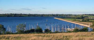
Draycote Water, Recreational reservoir in Warwickshire, England

Description

Draycote Water is a reservoir in Warwickshire with expansive water surface and walking paths circling the shore. The banks feature concrete and natural embankments that contain the water and support different recreational zones.

History

The reservoir was built in the late 1960s to supply water to Rugby and Coventry regions. Its completion marked the start of operations as a major water supply facility for the area.

Culture

The shoreline draws regular sailors, anglers, and bird watchers who pursue their hobbies across different seasons. These activities shape daily life at the water and create an active community of outdoor enthusiasts.

Practical

Multiple parking areas are available around the water and facilities including accessible toilets are on-site. The paths encircling the shore are well-maintained and suitable for various fitness levels.

Did you know?

The water body operates as a pumped storage system, receiving water from the River Leam during winter months. This hydraulic arrangement helps regulate water levels and maintain steady supply across the year.

Elevation above the sea
97 m
GPS coordinates
52.31727,-1.34127
Latest update
December 7, 2025 20:23

AroundUs brings together thousands of curated places, local tips, and hidden gems, enriched daily by 60,000 contributors worldwide. Discover all places nearby (United Kingdom).

Around this place
Birdingbury Hall
United Kingdom

Birdingbury Hall

1.8 km
Church of St Esprit
United Kingdom

Church of St Esprit

4.3 km
Church of All Saints, Leamington Hastings
United Kingdom

Church of All Saints, Leamington Hastings

1.5 km
Church of St Nicholas
United Kingdom

Church of St Nicholas

2.9 km
Church of St Leonard
United Kingdom

Church of St Leonard

1.8 km
Church of St Peter
United Kingdom

Church of St Peter

4.3 km
Church of St Peter
United Kingdom

Church of St Peter

1.8 km
Church of St Peter
United Kingdom

Church of St Peter

4.7 km
Statue of Lord John Douglas Montagu Douglas Scott
United Kingdom

Statue of Lord John Douglas Montagu Douglas Scott

4.2 km
The Shoulder of Mutton Public House
United Kingdom

The Shoulder of Mutton Public House

4.6 km
Woolscott Manor
United Kingdom

Woolscott Manor

4.9 km
Deerhurst And Attached Former Stables And Coach House  Madame Louise Hairdressers  The Old Post Office
United Kingdom

Deerhurst And Attached Former Stables And Coach House Madame Louise Hairdressers The Old Post Office

4.1 km
Post Office Stores And Inglenook
United Kingdom

Post Office Stores And Inglenook

4.1 km
Tudor House
United Kingdom

Tudor House

5.1 km
Dunchurch and Thurlaston War Memorial
United Kingdom

Dunchurch and Thurlaston War Memorial

4.2 km
The Windmill
United Kingdom

The Windmill

2.7 km
Birdingbury War Memorial
United Kingdom

Birdingbury War Memorial

2 km
Church House  Church Of St Edmund
United Kingdom

Church House Church Of St Edmund

2.7 km
Grand Union Canal, Shop Lock Approximately 7 Metres North Of Cottage Number 221
United Kingdom

Grand Union Canal, Shop Lock Approximately 7 Metres North Of Cottage Number 221

5 km
School House
United Kingdom

School House

2.2 km
Grand Union Canal, Stockton Locks, To The East Of Bridge Number 23 (Not Included)
United Kingdom

Grand Union Canal, Stockton Locks, To The East Of Bridge Number 23 (Not Included)

4.6 km
Village Hall
United Kingdom

Village Hall

2.3 km
Market Cross
United Kingdom

Market Cross

4.1 km
Marton Bridge
United Kingdom

Marton Bridge

4.3 km
Bourton-on-Dunsmore War Memorial
United Kingdom

Bourton-on-Dunsmore War Memorial

1.8 km
Milestone, 100m N of road to Grandborough
United Kingdom

Milestone, 100m N of road to Grandborough

5.2 km
Milestone, between Halfway Lane and entrance to Severn Trent Waterworks
United Kingdom

Milestone, between Halfway Lane and entrance to Severn Trent Waterworks

3.6 km
Milestone, opp."The Dun Cow" PH at crossroads with A426
United Kingdom

Milestone, opp."The Dun Cow" PH at crossroads with A426

4.1 km
Show the full map
« Draycote Water - Recreational reservoir in Warwickshire, England » is provided by Around Us (aroundus.com). Images and texts are derived from Wikimedia project under a Creative Commons license. You are allowed to copy, distribute, and modify copies of this page, under the conditions set by the license, as long as this note is clearly visible.

Discover hidden gems everywhere you go!

From secret cafés to breathtaking viewpoints, skip the crowded tourist spots and find places that match your style. Our app makes it easy with voice search, smart filtering, route optimization, and insider tips from travelers worldwide. Download now for the complete mobile experience.

Around Us App Screenshot

A unique approach to discovering new places

Le Figaro

All the places worth exploring

France Info

A tailor-made excursion in just a few clicks

20 Minutes

Around Us
Travel Guide & Maps
Download

Send to your phone

QR Code
1

Open the camera app on your mobile.

2

Point at the QR code with your camera. A notification will appear.

3

Tap the notification to open the link.