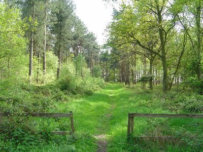
Allerthorpe Common, Nature reserve in East Riding of Yorkshire, England.
Allerthorpe Common is a protected site covering about 9 hectares in East Riding of Yorkshire with wet and dry heathland, mire, grassland, and woods. The landscape supports specialized plants like cross-leaved heath and heather, along with soils that developed under particular geological conditions.
The site received protection in 1951 after centuries of use as grazing land for cattle. Its designation recognized the scientific value of the natural habitats found here.
The site maintains its designation as a protected area, representing the commitment to preserve natural habitats in Yorkshire for scientific research.
The reserve is open to visitors wanting to observe wildlife including birds, reptiles, and plants in their natural setting. Bring appropriate footwear and clothing since the ground can be wet and uneven in places.
The ground here consists of acidic soils formed from river and lake sands deposited during the last glacial period around 12,000 years ago. This geological foundation allows plants that thrive only in these specific soil conditions to flourish.
GPS coordinates: 53.91850,-0.84205
Latest update: December 14, 2025 18:43
Burnby Hall Gardens
4.4 km
Church of All Saints, Pocklington
4.3 km
Derwent Ings
5.9 km
Sutton Bridge, Yorkshire
5.7 km
Church of Saint Botolph
2.4 km
Church of St John the Baptist
4.5 km
Church of Saint Michael and All Angels
5.6 km
Church of Saint Martin
5.2 km
Church of St Michael
2.4 km
Church of St Catherine
2 km
Church of St Martin
5.8 km
Church of St Giles
4.7 km
Hagg Bridge
5.1 km
Gardham Lock And Swing Bridge
3.9 km
Church Bridge
4.5 km
Pocklington Canal Top Lock And Canal Head
3.8 km
Pocklington Arts Centre
4.4 km
Railway Station
4.2 km
Pocklington Canal Walbut Lock
3.5 km
Pocklington Canal Coat's Bridge
3.3 km
Pocklington Canal Church Bridge
3.2 km
Pocklington Canal Thornton Lock
3.2 km
Pocklington Canal Walbut Bridge
3.5 km
Pocklington Canal Coat's Lock
3.3 km
Milestone Opposite The Squirrels Public House
2.3 km
Pocklington Canal Sandhill Lock
3.2 km
Milestone And Mounting Block About 75 Metres South-East Of Southmoor House
4.8 km
Milestone, Main Street Wilberfoss
4.9 kmVisited this place? Tap the stars to rate it and share your experience / photos with the community! Try now! You can cancel it anytime.
Discover hidden gems everywhere you go!
From secret cafés to breathtaking viewpoints, skip the crowded tourist spots and find places that match your style. Our app makes it easy with voice search, smart filtering, route optimization, and insider tips from travelers worldwide. Download now for the complete mobile experience.
A unique approach to discovering new places❞
— Le Figaro
All the places worth exploring❞
— France Info
A tailor-made excursion in just a few clicks❞
— 20 Minutes