Chest opened
+${chestReward.xp} XP
Explorer
NOUVEAU ×${chestReward.collectible.quantity}
tapez pour fermer
Chest locked

Open chests in the app

Around Us is built for your phone — chests unlock when you walk, explore and capture nearby places.

Enable Location

We need your location to show you interesting places around you

Discover nearby places

Find interesting locations and hidden gems around you

Precise directions

Get accurate directions and distances to places

Your location is never shared with other users. It's only used when you tap the location button.

Log in to your account

Start exploring — it's free

Trusted by 72,986 travelers worldwide

Continue with Google
Continue with Apple
or

We will send you a code to connect

By continuing, you accept our Terms and Conditions and our Privacy Policy

Check your inbox

We've sent a pincode in your inbox. Please enter the code below.

Admiralty M-N Scheme
Discussion Reviews Photo
3.9k Popularity

Admiralty M-N Scheme, Naval defense system in Dover Strait, United Kingdom.

The Admiralty M-N Scheme was a defense system made of concrete and steel towers connected by submarine nets across the Dover Strait. The structure was designed to form a continuous barrier that would control shipping and prevent enemy vessels from passing through the channel.

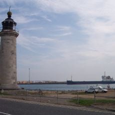
The system was developed by the British Admiralty in 1917 to counter German U-boats during World War I. Only two towers were actually constructed, as the ambitious project was never fully completed.

The project represents British naval engineering innovation, demonstrating the nation's commitment to protecting maritime routes during wartime operations.

The two towers that were built stand in different locations, with one later converted into a lighthouse. Visitors should know that these structures sit in the water and can only be reached from specific vantage points on shore or by boat.

One of the towers was later converted into the Nab Tower lighthouse near Bembridge and continues to function as a navigation aid today. This transformation shows how British engineers adapted the original military structures for peaceful purposes.

The community of curious travelers

AroundUs brings together thousands of curated places, local tips, and hidden gems, enriched daily by 60,000 contributors worldwide.

Start exploring
GPS coordinates
50.83600,-0.23900
Latest update
December 11, 2025 18:06
Reviews
Share your experience

No review yet

Discussions
Start a discussion...

No discussion yet

« Admiralty M-N Scheme - Naval defense system in Dover Strait, United Kingdom » is provided by Around Us (aroundus.com). Images and texts are derived from Wikimedia project under a Creative Commons license. You are allowed to copy, distribute, and modify copies of this page, under the conditions set by the license, as long as this note is clearly visible.

Discover hidden gems everywhere you go!

From secret cafés to breathtaking viewpoints, skip the crowded tourist spots and find places that match your style. Our app makes it easy with voice search, smart filtering, route optimization, and insider tips from travelers worldwide. Download now for the complete mobile experience.

Around Us App Screenshot

A unique approach to discovering new places

Le Figaro

All the places worth exploring

France Info

A tailor-made excursion in just a few clicks

20 Minutes

Around Us
Travel Guide & Maps
Download

Send to your phone

QR Code
1

Open the camera app on your mobile.

2

Point at the QR code with your camera. A notification will appear.

3

Tap the notification to open the link.