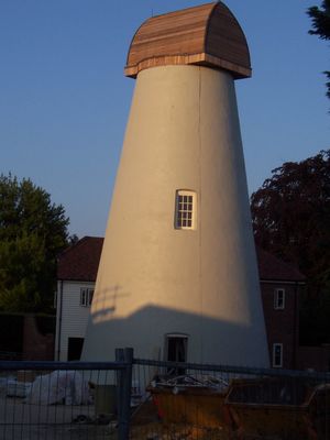
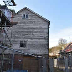
Bidborough Windmill, Tower mill in Bidborough, England.
Bidborough Windmill is a four-story brick tower that has stood on Penshurst Road since 1858, characterized by its cylindrical form and cement rendering. The structure retains a restored cap and maintains the typical proportions of a traditional grain mill tower.
Built in 1858, the mill operated with four patent sails until a lightning strike in 1900 damaged two of its wooden components. After this incident, mechanical and motorised equipment gradually took over grain-processing tasks, and the structure ceased active milling.
The mill has long shaped the community's visual identity and reminds locals of an era when such structures were essential to daily life. People in the area associate it with the heritage of self-sufficiency and collective wellbeing that once defined their neighbourhood.
The mill was converted to residential housing in 2006 and now forms part of a housing development, so it is visible from outside but not accessible to the public. Visitors can view its shape and structure from the public road and understand how such buildings have been adapted for modern use.
The mill was equipped with an external pulley system that allowed grain processing to be powered by a tractor or traction engine connected to the tower. This adaptive approach reveals how millers tried to extend the working life of their machinery by adopting newer power sources before finally abandoning operations.
The community of curious travelers
AroundUs brings together thousands of curated places, local tips, and hidden gems, enriched daily by 60,000 contributors worldwide.