Chest opened
+${chestReward.xp} XP
Explorer
NOUVEAU ×${chestReward.collectible.quantity}
tapez pour fermer
Chest locked

Open chests in the app

Around Us is built for your phone — chests unlock when you walk, explore and capture nearby places.

Enable Location

We need your location to show you interesting places around you

Discover nearby places

Find interesting locations and hidden gems around you

Precise directions

Get accurate directions and distances to places

Your location is never shared with other users. It's only used when you tap the location button.

Bilsdale transmitting station

Log in to your account

Start exploring — it's free

Trusted by 72,980 travelers worldwide

Continue with Google
Continue with Apple
or

We will send you a code to connect

By continuing, you accept our Terms and Conditions and our Privacy Policy

Check your inbox

We've sent a pincode in your inbox. Please enter the code below.

Bilsdale transmitting station
Discussion Reviews 1 Photos
11.4k Popularity

Bilsdale transmitting station, Transmission station in North Yorkshire, England

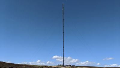
Bilsdale transmitting station is a broadcasting facility located on high ground in the Ryedale area of North Yorkshire. The installation features a tall mast structure designed to distribute television and radio signals across the surrounding region.

The original station was built in the late 1960s and supplied signals to northern England for decades. A fire in 2021 damaged the structure, leading to its replacement with a modern facility.

The station delivers television and radio signals to one million residents across York, Darlington, Stockton, Middlesbrough, Hartlepool, Sunderland, and Harrogate regions.

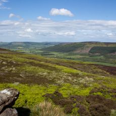
The station sits in an isolated hilltop location, so access is limited to designated paths and viewing areas. Visitors should allow extra time for travel and be prepared for changing weather conditions.

During reconstruction after the fire, a temporary shorter mast kept broadcasts running while the permanent structure was being built. This demonstrates how broadcasters must maintain service even through major disruptions.

The community of curious travelers

AroundUs brings together thousands of curated places, local tips, and hidden gems, enriched daily by 60,000 contributors worldwide.

Start exploring
GPS coordinates
54.35860,-1.15028
Latest update
December 8, 2025 13:40
Around this place
Cleveland Hills
United Kingdom

Cleveland Hills

7.2 km
Carlton Bank
United Kingdom

Carlton Bank

7.2 km
Church of St Nicholas
United Kingdom

Church of St Nicholas

7.1 km
Church of All Saints
United Kingdom

Church of All Saints

6.8 km
Church of St Hilda
United Kingdom

Church of St Hilda

4.7 km
Church of St Mary Magdelene
United Kingdom

Church of St Mary Magdelene

8.2 km
K6 Outside St Mary Magdelene's Church
United Kingdom

K6 Outside St Mary Magdelene's Church

8.1 km
Spout House
United Kingdom

Spout House

3.4 km
Arden Hall
United Kingdom

Arden Hall

6.5 km
Green K6 Telephone Kiosk At Fangdale Beck Junction
United Kingdom

Green K6 Telephone Kiosk At Fangdale Beck Junction

2.5 km
Roppa South Cross on Carr Cote Ridge 1100m WSW of Piethorn
United Kingdom

Roppa South Cross on Carr Cote Ridge 1100m WSW of Piethorn

5 km
Easterside Farmhouse
United Kingdom

Easterside Farmhouse

6.6 km
Guidestone
United Kingdom

Guidestone

5.9 km
Cockan Cross wayside cross 600m west of Fox Hole Crag
United Kingdom

Cockan Cross wayside cross 600m west of Fox Hole Crag

8.3 km
Jenny Bradley Stone
United Kingdom

Jenny Bradley Stone

8.4 km
Section of the Cleave Dyke system on Arden Little Moor known as Steeple Cross Dyke including the Steeple Cross boundary stone
United Kingdom

Section of the Cleave Dyke system on Arden Little Moor known as Steeple Cross Dyke including the Steeple Cross boundary stone

7.9 km
Green Howe round barrow
United Kingdom

Green Howe round barrow

2.9 km
Wayside cross known as Stump Cross on Bransdale Ridge
United Kingdom

Wayside cross known as Stump Cross on Bransdale Ridge

5.7 km
Round barrow at Drake Howe
United Kingdom

Round barrow at Drake Howe

6.9 km
Cammon Stone
United Kingdom

Cammon Stone

8.2 km
Chop Gate WWI Memorial
United Kingdom

Chop Gate WWI Memorial

3.6 km
Bloworth Guidestone
United Kingdom

Bloworth Guidestone

8.2 km
Wayside cross 950m east of Spout House Plantation
United Kingdom

Wayside cross 950m east of Spout House Plantation

4.7 km
Guidestone, The Hand Stone, Round Hill, Urra Moor
United Kingdom

Guidestone, The Hand Stone, Round Hill, Urra Moor

6.7 km
Cock Howe round barrow
United Kingdom

Cock Howe round barrow

2.4 km
Guidestone, Bilsdale,nr entrance to Helm House
United Kingdom

Guidestone, Bilsdale,nr entrance to Helm House

3.8 km
Guidestone, Cammon Stone, Rudland Rigg
United Kingdom

Guidestone, Cammon Stone, Rudland Rigg

8.2 km
Guidestone, Bilsdale, near Low Mill
United Kingdom

Guidestone, Bilsdale, near Low Mill

2.1 km
Show the full map
Reviews
Share your experience

No review yet

Discussions
Start a discussion...

No discussion yet

« Bilsdale transmitting station - Transmission station in North Yorkshire, England » is provided by Around Us (aroundus.com). Images and texts are derived from Wikimedia project under a Creative Commons license. You are allowed to copy, distribute, and modify copies of this page, under the conditions set by the license, as long as this note is clearly visible.

Discover hidden gems everywhere you go!

From secret cafés to breathtaking viewpoints, skip the crowded tourist spots and find places that match your style. Our app makes it easy with voice search, smart filtering, route optimization, and insider tips from travelers worldwide. Download now for the complete mobile experience.

Around Us App Screenshot

A unique approach to discovering new places

Le Figaro

All the places worth exploring

France Info

A tailor-made excursion in just a few clicks

20 Minutes

Around Us
Travel Guide & Maps
Download

Send to your phone

QR Code
1

Open the camera app on your mobile.

2

Point at the QR code with your camera. A notification will appear.

3

Tap the notification to open the link.