Chest opened
+${chestReward.xp} XP
Explorer
NOUVEAU ×${chestReward.collectible.quantity}
tapez pour fermer
Chest locked

Open chests in the app

Around Us is built for your phone — chests unlock when you walk, explore and capture nearby places.

Enable Location

We need your location to show you interesting places around you

Discover nearby places

Find interesting locations and hidden gems around you

Precise directions

Get accurate directions and distances to places

Your location is never shared with other users. It's only used when you tap the location button.

Brea Hill

Log in to your account

Start exploring — it's free

Trusted by 72,890 travelers worldwide

Continue with Google
Continue with Apple
or

We will send you a code to connect

By continuing, you accept our Terms and Conditions and our Privacy Policy

Check your inbox

We've sent a pincode in your inbox. Please enter the code below.

Brea Hill
Discussion Reviews 1 Photos
1.7k Popularity

Brea Hill, hill in Cornwall, England

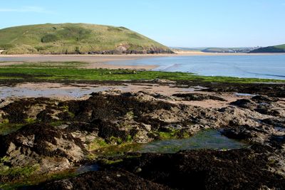
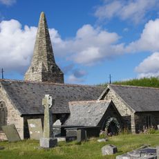
Brea Hill is a rounded summit overlooking the River Camel estuary in north Cornwall, rising to about 62 meters (203 feet). The grassy top sits above underlying Devonian slates with a dolerite dyke visible from the west side, and Bronze Age burial mounds mark the summit.

The burial mounds at the summit date to Bronze Age times, showing that people used this location for important burials thousands of years ago. The underlying slate rock formation developed over millions of years during the Devonian period.

The hill has been a place of importance since Bronze Age times, when people built burial mounds here. These structures show that the site held meaning for ancient communities who lived in this part of Cornwall.

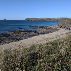
The hill is accessible via the South West Coast Path and offers a gentle climb suitable for most visitors. The grassy summit and surrounding grassland make for easy walking, and the open terrain provides clear views without obstruction.

A dark dolerite dyke cuts through the slate of the hill and is visible from the west side or from a nearby quarry. This geological feature adds hidden complexity to what appears as a simple rounded hill from afar.

The community of curious travelers

AroundUs brings together thousands of curated places, local tips, and hidden gems, enriched daily by 60,000 contributors worldwide.

Start exploring
Address
Wadebridge PL27 6SH, UK
GPS coordinates
50.55716,-4.92605
Latest update
January 9, 2026 12:33
Around this place
St Enodoc's Church, Trebetherick
United Kingdom

St Enodoc's Church, Trebetherick

338 m
United Kingdom

Tombchest Of Simon Wilcox 6 Metres To South Of South Porch Of Church Of St Enodoc

327 m
The Shipwrights
United Kingdom

The Shipwrights

1.8 km
Greenaway Beach
United Kingdom

Greenaway Beach

1.2 km
Abbey House
United Kingdom

Abbey House

1.9 km
Padstow War Memorial
United Kingdom

Padstow War Memorial

1.3 km
Tregirls Cottages
United Kingdom

Tregirls Cottages

1.8 km
North Quay Walls
United Kingdom

North Quay Walls

1.8 km
United Kingdom

Rock Sailing Club House

1.6 km
United Kingdom

Garden Walls To Oak Terrace

1.9 km
United Kingdom

Quay To West, South And East Of Rock Sailing Club House And Adoining Walls To Beach On West And East

1.6 km
United Kingdom

Headstone Of John Edvvean 2 Metres To South Of South Aisle Of Church Of St Enodoc

335 m
United Kingdom

Jesus Well

1.2 km
United Kingdom

Harbour Walls Comprising Walls To South Of North Quay, To East Of The Strand And To North Of South Quay, Slips And Pier On North East Of South Quay

1.9 km
HMS Warwick Memorial, Padstow
United Kingdom

HMS Warwick Memorial, Padstow

1.8 km
United Kingdom

Lancefield House

1.9 km
United Kingdom

20, St Saviours Lane

1.9 km
United Kingdom

Harbour Walls At The 'Old Boat Yard'

1.6 km
United Kingdom

Ellerys And R T G Broad

1.9 km
United Kingdom

Harbour View Harbour View Crafts And Thoughts

1.9 km
United Kingdom

Red Brick Warehouse Directly To East Of The Shipwrights

1.8 km
United Kingdom

Two Tombchests Of Richard Rounsevall And Mary Ken, 3 Metres To East Of North Tower Of Church Of St Enodoc

340 m
United Kingdom

Undertown Including Terrace Walls And Sunken Garden Walls West, South And South West

716 m
United Kingdom

The Flower Shop The Old Mill Gifts

1.9 km
United Kingdom

St Enodoc Golf Club

711 m
United Kingdom

Jutty

758 m
United Kingdom

Headstone Of John Mably 7 Metres To North East Of Chancel Of Church Of St Enodoc

351 m

Gully

966 m
Show the full map
Reviews
Share your experience

No review yet

Discussions
Start a discussion...

No discussion yet

« Brea Hill - hill in Cornwall, England » is provided by Around Us (aroundus.com). Images and texts are derived from Wikimedia project under a Creative Commons license. You are allowed to copy, distribute, and modify copies of this page, under the conditions set by the license, as long as this note is clearly visible.

Discover hidden gems everywhere you go!

From secret cafés to breathtaking viewpoints, skip the crowded tourist spots and find places that match your style. Our app makes it easy with voice search, smart filtering, route optimization, and insider tips from travelers worldwide. Download now for the complete mobile experience.

Around Us App Screenshot

A unique approach to discovering new places

Le Figaro

All the places worth exploring

France Info

A tailor-made excursion in just a few clicks

20 Minutes

Around Us
Travel Guide & Maps
Download

Send to your phone

QR Code
1

Open the camera app on your mobile.

2

Point at the QR code with your camera. A notification will appear.

3

Tap the notification to open the link.