Chest opened
+${chestReward.xp} XP
Explorer
NOUVEAU ×${chestReward.collectible.quantity}
tapez pour fermer
Chest locked

Open chests in the app

Around Us is built for your phone — chests unlock when you walk, explore and capture nearby places.

Enable Location

We need your location to show you interesting places around you

Discover nearby places

Find interesting locations and hidden gems around you

Precise directions

Get accurate directions and distances to places

Your location is never shared with other users. It's only used when you tap the location button.

Brent Hill

Log in to your account

Start exploring — it's free

Trusted by 72,882 travelers worldwide

Continue with Google
Continue with Apple
or

We will send you a code to connect

By continuing, you accept our Terms and Conditions and our Privacy Policy

Check your inbox

We've sent a pincode in your inbox. Please enter the code below.

Discussion Reviews 1 Photos
1.2k Popularity

Brent Hill, Iron Age hillfort in South Brent, England

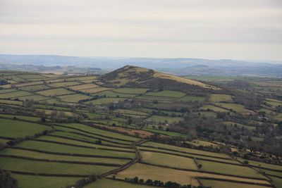
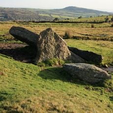
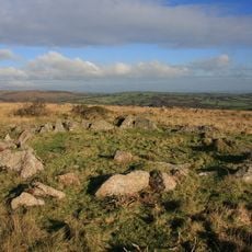
Brent Hill is an Iron Age hillfort with three prominent crags forming the summit area in South Devon. The location rises to approximately 311 meters and provides views across the surrounding South Hams region.

The hillfort was built around 500 BC as part of an Iron Age defensive system. Later, it may have served as a lookout point during historical threats to the region.

Since 1972, people have carried wooden crosses to the summit rocks during Good Friday, creating a gathering tradition at this location. This practice shows how the place holds spiritual meaning for visitors today.

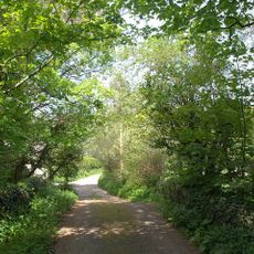
Access is available from the northwest side via established tracks or from the south through a path across farmland. Visitors should be prepared for uneven ground and exposed rocky sections.

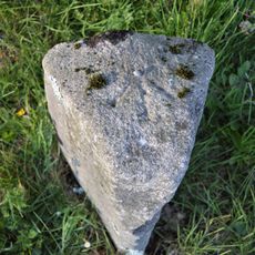
A balanced boulder rests prominently on the southernmost crag and is visible from the northeast side near the survey marker. This naturally shaped stone stands out as a distinctive landmark on the hilltop.

The community of curious travelers

AroundUs brings together thousands of curated places, local tips, and hidden gems, enriched daily by 60,000 contributors worldwide.

Start exploring
Location
GPS coordinates
50.44059,-3.82779
Latest update
December 14, 2025 18:20
Around this place
Church of St Petrock
United Kingdom

Church of St Petrock

1.6 km
Church of St George
United Kingdom

Church of St George

3.3 km
Pennaton Bridge
United Kingdom

Pennaton Bridge

3 km
Bridge Immediately South East Of Glazebrook Lodge
United Kingdom

Bridge Immediately South East Of Glazebrook Lodge

2.9 km
Lydia Bridge
United Kingdom

Lydia Bridge

1.3 km
Devil's Backbone Bridge
United Kingdom

Devil's Backbone Bridge

3.4 km
Shipley Bridge
United Kingdom

Shipley Bridge

2.5 km
Brent Mill Bridge
United Kingdom

Brent Mill Bridge

2.2 km
Owley Bridge
United Kingdom

Owley Bridge

3.1 km
Syon Abbey
United Kingdom

Syon Abbey

2.2 km
Rattery Viaduct
United Kingdom

Rattery Viaduct

3.1 km
Glaze Brook Bridge
United Kingdom

Glaze Brook Bridge

2.9 km
Guidestone, Aish Cross, corner of Aish Lane, 400m W of Old Brent Mill Bridge on old road to Wrangaton
United Kingdom

Guidestone, Aish Cross, corner of Aish Lane, 400m W of Old Brent Mill Bridge on old road to Wrangaton

2.4 km
Footbridge 100 M North-East Of Courtledge Cottage
United Kingdom

Footbridge 100 M North-East Of Courtledge Cottage

1.6 km
Chambered cairn at Ball Gate, Corringdon Ball
United Kingdom

Chambered cairn at Ball Gate, Corringdon Ball

3.4 km
Barn And Shippon Immediately West Of Owley Farmhouse
United Kingdom

Barn And Shippon Immediately West Of Owley Farmhouse

3.4 km
Stone hut circle on Corringdon Ball
United Kingdom

Stone hut circle on Corringdon Ball

3.3 km
Rattery Mill And Millhouse
United Kingdom

Rattery Mill And Millhouse

3.1 km
The Rock Including Gateway Adjoining South
United Kingdom

The Rock Including Gateway Adjoining South

1.2 km
Guidestone, Moor Cross, at jct of 2 roads and a track, just NW of Reddacleave Kiln Cross
United Kingdom

Guidestone, Moor Cross, at jct of 2 roads and a track, just NW of Reddacleave Kiln Cross

2.3 km
Milestone, Marley Head , eastern roundabout, by private exit to N
United Kingdom

Milestone, Marley Head , eastern roundabout, by private exit to N

2.2 km
Milestone, Aish, centre of village,by "Long Barn", opp. "Treeby", 15m S of telephone/post box
United Kingdom

Milestone, Aish, centre of village,by "Long Barn", opp. "Treeby", 15m S of telephone/post box

1.5 km
Gatepier and Guidestone at Aish Cross, corner of Aish Lane
United Kingdom

Gatepier and Guidestone at Aish Cross, corner of Aish Lane

2.4 km
Milestone, E end of old Brent Bridge, just off B3372, nr old toll house
United Kingdom

Milestone, E end of old Brent Bridge, just off B3372, nr old toll house

2.2 km
Milestone, dual carriageway, S-bound lay-by, half mile E of Marley Head
United Kingdom

Milestone, dual carriageway, S-bound lay-by, half mile E of Marley Head

2.2 km
Milestone, 50m W of entrance to Turtley Mill PH
United Kingdom

Milestone, 50m W of entrance to Turtley Mill PH

2.9 km
Milestone, Avonwick, South Brent Road, NW edge of village
United Kingdom

Milestone, Avonwick, South Brent Road, NW edge of village

3.4 km
Guidestone, Clampits Stile, jct near Moorhead
United Kingdom

Guidestone, Clampits Stile, jct near Moorhead

2.4 km
Show the full map
Reviews
Share your experience

No review yet

Discussions
Start a discussion...

No discussion yet

« Brent Hill - Iron Age hillfort in South Brent, England » is provided by Around Us (aroundus.com). Images and texts are derived from Wikimedia project under a Creative Commons license. You are allowed to copy, distribute, and modify copies of this page, under the conditions set by the license, as long as this note is clearly visible.

Discover hidden gems everywhere you go!

From secret cafés to breathtaking viewpoints, skip the crowded tourist spots and find places that match your style. Our app makes it easy with voice search, smart filtering, route optimization, and insider tips from travelers worldwide. Download now for the complete mobile experience.

Around Us App Screenshot

A unique approach to discovering new places

Le Figaro

All the places worth exploring

France Info

A tailor-made excursion in just a few clicks

20 Minutes

Around Us
Travel Guide & Maps
Download

Send to your phone

QR Code
1

Open the camera app on your mobile.

2

Point at the QR code with your camera. A notification will appear.

3

Tap the notification to open the link.