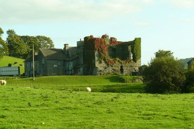
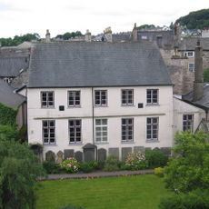
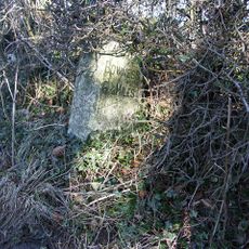
Burneside Hall, Medieval pele tower in Strickland Roger, England
Burneside Hall is a medieval pele tower standing in Strickland Roger with three stories and sturdy stone walls. The structure contains two vaulted chambers at ground level connected by a narrow passage that you can still see today.
The site was founded around 1290 when Gilbert Burneshead, Under-Sheriff of Westmorland, built the original structure. The Bellingham family later gained ownership through marriage and held the property across many generations.
The building served as a family stronghold for centuries, providing both shelter and security for those who lived and worked there. Walking around the remains, you can sense how medieval families adapted their homes to protect themselves in this border region.
The building remains part of an active farm, so access may be limited and you should check before visiting. Wear sturdy footwear as the site has uneven ground and the old stonework requires careful footing.
Wood samples from the structure revealed that different parts were built and rebuilt across several centuries, with timber elements ranging from the early 1400s through the late 1600s. This patchwork of building dates shows how the structure was constantly maintained and adapted by its owners over time.
Location: Strickland Roger
GPS coordinates: 54.35610,-2.75560
Latest update: December 14, 2025 12:22
Kendal Museum
2.9 km
County Offices
2.8 km
St George's Church, Kendal
3.1 km
St Thomas' Church, Kendal
2.8 km
The Castle Dairy
3 km
Friends Meeting House
3.2 km
Globe Inn
3.1 km
War Memorial
3.1 km
St Oswald's Church
537 m
Elba Monument
1.5 km
St John the Baptist's Church
2 km
Milestone On Loop Road 50 Yards South Of Junction Of Hollins Lane And Windermere
1.6 km
Unitarian Chapel And Schoolroom To North East Of Number 40
3.1 km
Kendal Library
3 km
George And Dragon
3.2 km
98, Stricklandgate
3 km
Stramongate Bridge
3 km
Stricklandgate House
3 km
Woolpack Inn And Entrance To Yard 56
3.1 km
27, Stricklandgate
3.1 km
90, Stricklandgate
3 km
Gateway To South Of Tolson Hall And Attached Walls
1.2 km
Milestone In Layby To Left Of A591 200 Metres North Of Ratherheath Lane
2.4 km
Ywca
2.9 km
No. 69 And Entrance To Yard 67
3 km
No.108 And Passage Entry To No.110
2.9 km
Milestone, Plumgarth roundabout; opp. 'Cunswick End'
2 km
Milestone, Windermere Road, at top of hill out of Kendall, by Airey's Folly
2 kmVisited this place? Tap the stars to rate it and share your experience / photos with the community! Try now! You can cancel it anytime.
Discover hidden gems everywhere you go!
From secret cafés to breathtaking viewpoints, skip the crowded tourist spots and find places that match your style. Our app makes it easy with voice search, smart filtering, route optimization, and insider tips from travelers worldwide. Download now for the complete mobile experience.
A unique approach to discovering new places❞
— Le Figaro
All the places worth exploring❞
— France Info
A tailor-made excursion in just a few clicks❞
— 20 Minutes