Enable Location

We need your location to show you interesting places around you

Discover nearby places

Find interesting locations and hidden gems around you

Precise directions

Get accurate directions and distances to places

Your location is never shared with other users. It's only used when you tap the location button.

Caerau Hillfort

Log in to your account

Start exploring — it's free

Trusted by 62,168 travelers worldwide

Continue with Google
Continue with Apple
or

We will send you a code to connect

By continuing, you accept our Terms and Conditions and our Privacy Policy

Check your inbox

We've sent a pincode in your inbox. Please enter the code below.

Caerau Hillfort

Caerau Hillfort, Iron Age hillfort in Cardiff, Wales

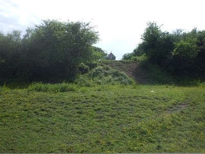
Caerau Hillfort is an Iron Age fort sitting on a ridge with a three-sided defensive design made from large earth ramparts and ditches. The layout covers substantial ground and shows how people shaped the natural slope to create protective walls around the settlement.

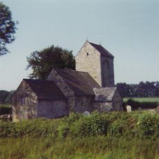
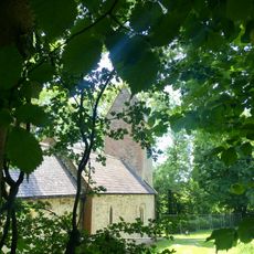
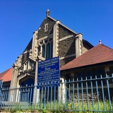
Humans lived here continuously from the Neolithic period through the Iron Age, with the major defensive walls built during the Iron Age occupation. A medieval church was later built within the ancient ramparts, showing how the site remained important across different eras.

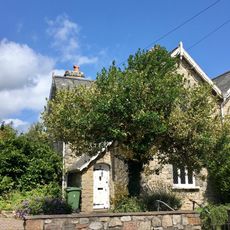
St Mary's Church occupies the interior of the fort since medieval times, marking the site as a place of worship for centuries. The stone structure shows how different periods of history layered themselves onto this single location.

You can enter from the eastern side or near the southern corner, and the ground is open for walking, though grass and soil vary across the slopes. Wear sturdy shoes since you will be stepping on uneven terrain and climbing the earth ramparts to see the layout clearly.

Excavations turned up flint tools and Roman pottery, including a first-century pouring vessel found near the north entrance. These finds suggest that even after the fort's main period, people from different backgrounds continued to move through and leave traces at this location.

The community of curious travelers

AroundUs brings together thousands of curated places, local tips, and hidden gems, enriched daily by 60,000 contributors worldwide.

Start exploring
GPS coordinates
51.46738,-3.24896
Latest update
December 12, 2025 07:54
Around this place
St Mary the Virgin Church
United Kingdom

St Mary the Virgin Church

170 m
Wrinstone
United Kingdom

Wrinstone

2.4 km
Church of the Resurrection
United Kingdom

Church of the Resurrection

1.3 km
Church of St. Francis of Assisi RC
United Kingdom

Church of St. Francis of Assisi RC

804 m
Church of St Michael
United Kingdom

Church of St Michael

2.3 km
Ely Methodist Church
United Kingdom

Ely Methodist Church

2 km
Milepost outside the Western Cemetery
United Kingdom

Milepost outside the Western Cemetery

1.2 km
Former St Fagans Church in Wales Primary School
United Kingdom

Former St Fagans Church in Wales Primary School

2.5 km
St David's Church
United Kingdom

St David's Church

1.8 km
Wenvoe Library
United Kingdom

Wenvoe Library

2.4 km
St. Fagans Court (also known as The Court)
United Kingdom

St. Fagans Court (also known as The Court)

1.7 km
Milepost outside No 322
United Kingdom

Milepost outside No 322

1 km
Milepost on railway bridge
United Kingdom

Milepost on railway bridge

2.4 km
4, Castle Hill, St Fagans, Cardiff
United Kingdom

4, Castle Hill, St Fagans, Cardiff

2.5 km
Stable Court at St Fagans Castle
United Kingdom

Stable Court at St Fagans Castle

2.5 km
1, Cardiff Road, St Fagans, Cardiff
United Kingdom

1, Cardiff Road, St Fagans, Cardiff

2.5 km
Former Stables at Tŷ Bronna
United Kingdom

Former Stables at Tŷ Bronna

2.4 km
Front Garden Walls of Nos 1-4 (consec)
United Kingdom

Front Garden Walls of Nos 1-4 (consec)

2.5 km
Silver Stream
United Kingdom

Silver Stream

2.5 km
Nos. 1-4 (Consec) & Front Garden Walls, Castle Hill, St Fagans
United Kingdom

Nos. 1-4 (Consec) & Front Garden Walls, Castle Hill, St Fagans

2.5 km
Nos. 1-4 (Consec) & Front Garden Walls, Castle Hill, St Fagans
United Kingdom

Nos. 1-4 (Consec) & Front Garden Walls, Castle Hill, St Fagans

2.5 km
Front Garden Wall
United Kingdom

Front Garden Wall

2.5 km
3, Castle Hill, St Fagans, Cardiff
United Kingdom

3, Castle Hill, St Fagans, Cardiff

2.5 km
Garden Walls of Nos. 3 & 4
United Kingdom

Garden Walls of Nos. 3 & 4

2.5 km
The Mount
United Kingdom

The Mount

2.5 km
2,Cardiff Road, St Fagans,Cardiff
United Kingdom

2,Cardiff Road, St Fagans,Cardiff

2.5 km
South Boundary Wall of the Stable Court including the Drinking Fountain on Castle Hill
United Kingdom

South Boundary Wall of the Stable Court including the Drinking Fountain on Castle Hill

2.5 km
Wall and Railings at former St Fagans Church in Wales School
United Kingdom

Wall and Railings at former St Fagans Church in Wales School

2.5 km
Show the full map
« Caerau Hillfort - Iron Age hillfort in Cardiff, Wales » is provided by Around Us (aroundus.com). Images and texts are derived from Wikimedia project under a Creative Commons license. You are allowed to copy, distribute, and modify copies of this page, under the conditions set by the license, as long as this note is clearly visible.

Discover hidden gems everywhere you go!

From secret cafés to breathtaking viewpoints, skip the crowded tourist spots and find places that match your style. Our app makes it easy with voice search, smart filtering, route optimization, and insider tips from travelers worldwide. Download now for the complete mobile experience.

Around Us App Screenshot

A unique approach to discovering new places

Le Figaro

All the places worth exploring

France Info

A tailor-made excursion in just a few clicks

20 Minutes

Around Us
Travel Guide & Maps
Download

Send to your phone

QR Code
1

Open the camera app on your mobile.

2

Point at the QR code with your camera. A notification will appear.

3

Tap the notification to open the link.