Caesar's Camp, Bracknell Forest

Log in to your account

AroundUs is a community-driven map of interesting places, built by curious explorers like you. It grows with every review, story, and photo you share.
Connect to save your favorite spots, contribute locations, and create personalized routes.
Continue with Google
Continue with Apple
Continue with X
Continue with Facebook
Continue with email
By continuing, you accept our Terms and Conditions and our Privacy Policy
Create an account
Add to collection
Map
Suggest a change
Share

Caesar's Camp, Bracknell Forest, Iron Age hillfort in Crowthorne, England

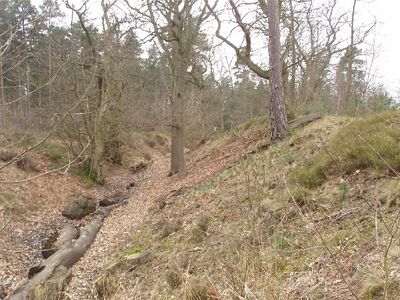
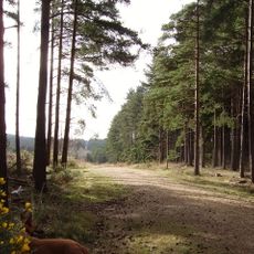
Caesar's Camp is an Iron Age fortification set within woodland, defined by steep ramparts and defensive ditches arranged in an oak-leaf pattern enclosing a flat central space. The site covers around 17 acres and functions today as a nature reserve within the Crown Estate.

The fortification was built between 500 and 300 BC and served as a gathering and trading point for local tribes. When Roman forces arrived in the 1st century AD, the site lost its importance to the region.

The name references Roman times, though the fort was built centuries before that conquest. Walking through the site today, you can see how the landscape itself tells the story of Iron Age settlement and community gathering.

The site is managed for public access, though dogs must be kept on leads during the nesting season from March through September. The wooded setting means paths can become muddy, especially after rain.

A geophysical survey from 1995 revealed signs of extended occupation across the site. This discovery was never followed by major excavation work, leaving many questions about what lies beneath the ground.

Location: Crowthorne

Website: https://bracknell-forest.gov.uk/parks-and-countryside/parks-visit/caesars-camp

GPS coordinates: 51.38379,-0.76040

Latest update: December 10, 2025 20:06

Photos
Around this place
Bagshot Park Mansion
United Kingdom

Bagshot Park Mansion

4.7 km
Easthampstead Park
United Kingdom

Easthampstead Park

2.5 km
South Hill Park
United Kingdom

South Hill Park

1.3 km
St Michael and St Mary Magdalene's Church, Easthampstead
United Kingdom

St Michael and St Mary Magdalene's Church, Easthampstead

2 km
Broadmoor to Bagshot Woods and Heaths
United Kingdom

Broadmoor to Bagshot Woods and Heaths

1.9 km
The Look Out Discovery Centre Play Area
United Kingdom

The Look Out Discovery Centre Play Area

1.4 km
Church of St John The Baptist
United Kingdom

Church of St John The Baptist

3.1 km
Chapel At Wellington College With Porch Colonnade And Gateway Adjoining West End
United Kingdom

Chapel At Wellington College With Porch Colonnade And Gateway Adjoining West End

3.9 km
Church of St Anne
United Kingdom

Church of St Anne

5 km
Church of St Mark
United Kingdom

Church of St Mark

4.7 km
Old Building With Attached Lamps, Royal Military Academy
United Kingdom

Old Building With Attached Lamps, Royal Military Academy

4.9 km
Royal Memorial Chapel, Royal Military Academy
United Kingdom

Royal Memorial Chapel, Royal Military Academy

4.8 km
Ancient Well
United Kingdom

Ancient Well

4.9 km
St Martin's Church
United Kingdom

St Martin's Church

4.6 km
Monument to Napoléon, Prince Imperial
United Kingdom

Monument to Napoléon, Prince Imperial

4.5 km
The Red Lion Inn
United Kingdom

The Red Lion Inn

3.7 km
Moor Close
United Kingdom

Moor Close

4.8 km
Holy Trinity Church
United Kingdom

Holy Trinity Church

3.7 km
Sandhurst Library
United Kingdom

Sandhurst Library

4.9 km
Bagshot War Memorial, Surrey
United Kingdom

Bagshot War Memorial, Surrey

5 km
Milestone Approx 150M E Of The Running Horse Ph (Running Horse Ph Not Included)
United Kingdom

Milestone Approx 150M E Of The Running Horse Ph (Running Horse Ph Not Included)

3.9 km
Rackshaw Farmhouse
United Kingdom

Rackshaw Farmhouse

4.6 km
Bull Inn
United Kingdom

Bull Inn

3.7 km
The Staff College
United Kingdom

The Staff College

4.9 km
Milestone In Front Of The Red Lion Inn Near The Left Corner
United Kingdom

Milestone In Front Of The Red Lion Inn Near The Left Corner

3.7 km
Milestone Approx 50M East Of Junction With Swinley Road
United Kingdom

Milestone Approx 50M East Of Junction With Swinley Road

4.9 km
Milestone, traffic lights at jct of London Road with Caesar's Camp Road
United Kingdom

Milestone, traffic lights at jct of London Road with Caesar's Camp Road

5 km
Milepost, London Road; Clay Lane/ Waterloo Lodge, Frog Hall
United Kingdom

Milepost, London Road; Clay Lane/ Waterloo Lodge, Frog Hall

4.7 km
Show the full map
Reviews

Visited this place? Tap the stars to rate it and share your experience / photos with the community! Try now! You can cancel it anytime.

« Caesar's Camp, Bracknell Forest - Iron Age hillfort in Crowthorne, England » is provided by Around Us (aroundus.com). Images and texts are derived from Wikimedia project under a Creative Commons license. You are allowed to copy, distribute, and modify copies of this page, under the conditions set by the license, as long as this note is clearly visible.

Discover hidden gems everywhere you go!

From secret cafés to breathtaking viewpoints, skip the crowded tourist spots and find places that match your style. Our app makes it easy with voice search, smart filtering, route optimization, and insider tips from travelers worldwide. Download now for the complete mobile experience.

Around Us App Screenshot

A unique approach to discovering new places

Le Figaro

All the places worth exploring

France Info

A tailor-made excursion in just a few clicks

20 Minutes