Chest opened
+${chestReward.xp} XP
Explorer
NOUVEAU ×${chestReward.collectible.quantity}
tapez pour fermer
Chest locked

Open chests in the app

Around Us is built for your phone — chests unlock when you walk, explore and capture nearby places.

Enable Location

We need your location to show you interesting places around you

Discover nearby places

Find interesting locations and hidden gems around you

Precise directions

Get accurate directions and distances to places

Your location is never shared with other users. It's only used when you tap the location button.

Log in to your account

Start exploring — it's free

Trusted by 72,981 travelers worldwide

Continue with Google
Continue with Apple
or

We will send you a code to connect

By continuing, you accept our Terms and Conditions and our Privacy Policy

Check your inbox

We've sent a pincode in your inbox. Please enter the code below.

Castle Hill
Discussion Reviews Photo
23k Popularity

Castle Hill, Ancient hilltop settlement in Huddersfield, United Kingdom.

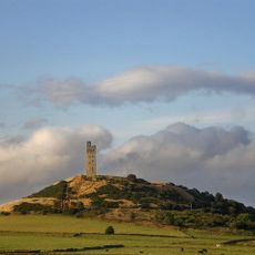
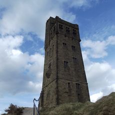
Castle Hill is a hilltop in Huddersfield featuring thick stone walls and the prominent Victoria Tower overlooking the Holme Valley. The summit offers views across the surrounding landscape and the town below.

The hill held human settlements for thousands of years, including an Iron Age fort and a Norman castle. Later uses ranged from a medieval village to stone quarrying and mining operations.

The Victoria Tower, built in 1899, stands as a memorial to Queen Victoria's Diamond Jubilee and has become the defining landmark of Huddersfield. Locals and visitors alike recognize it as the symbol of the town.

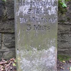
The summit is reached via designated footpaths starting from the car park at the base. Several routes of varying difficulty make it accessible to different fitness levels.

The hillside contains five visible coal seams within its rock layers, remnants of the area's industrial past. These layers tell the story of mining that once shaped the region's economy and landscape.

The community of curious travelers

AroundUs brings together thousands of curated places, local tips, and hidden gems, enriched daily by 60,000 contributors worldwide.

Start exploring
Location
GPS coordinates
53.62230,-1.77167
Latest update
December 20, 2025 15:10
Around this place
Tolson Museum
United Kingdom

Tolson Museum

2.7 km
Lawrence Batley Theatre
United Kingdom

Lawrence Batley Theatre

2.6 km
Huddersfield Town Hall Including Wall And Railings To Area
United Kingdom

Huddersfield Town Hall Including Wall And Railings To Area

2.5 km
Lockwood Viaduct
United Kingdom

Lockwood Viaduct

2 km
Huddersfield Library and Art Gallery
United Kingdom

Huddersfield Library and Art Gallery

2.6 km
St. Thomas's Church, Huddersfield
United Kingdom

St. Thomas's Church, Huddersfield

2.6 km
St Paul's Street drill hall, Huddersfield
United Kingdom

St Paul's Street drill hall, Huddersfield

2.3 km
Church of St Paul
United Kingdom

Church of St Paul

1.8 km
Milton Congregational Church
United Kingdom

Milton Congregational Church

2.3 km
Commercial Hotel
United Kingdom

Commercial Hotel

2.6 km
Parish Church of All Hallows, Almondbury
United Kingdom

Parish Church of All Hallows, Almondbury

1.9 km
Church of St Mary the Virgin
United Kingdom

Church of St Mary the Virgin

2.4 km
Church of St Lucius
United Kingdom

Church of St Lucius

1.8 km
The Woolpack Public House
United Kingdom

The Woolpack Public House

1.9 km
Almondbury Library
United Kingdom

Almondbury Library

1.8 km
Almondbury Castle Hill
United Kingdom

Almondbury Castle Hill

73 m
The Fly Boat Public House
United Kingdom

The Fly Boat Public House

2.3 km
Victoria Tower
United Kingdom

Victoria Tower

38 m
Cross Socket On South Side To Fenny Hall
United Kingdom

Cross Socket On South Side To Fenny Hall

2.7 km
Milestone Opposite Drive To Number 198
United Kingdom

Milestone Opposite Drive To Number 198

2.2 km
Milestone, Somerset Road, opp. Benomley Road, Almondbury
United Kingdom

Milestone, Somerset Road, opp. Benomley Road, Almondbury

2 km
Milestone, Woodhead Road, S of Berry Brow
United Kingdom

Milestone, Woodhead Road, S of Berry Brow

1.5 km
4 Miles Post Opposite Junction With Far End Lane
United Kingdom

4 Miles Post Opposite Junction With Far End Lane

2.6 km
Ravensknowle Hall
United Kingdom

Ravensknowle Hall

2.7 km
Arts Centre Including Dwarf Wall Enclosing Queens Square
United Kingdom

Arts Centre Including Dwarf Wall Enclosing Queens Square

2.6 km
Wormalls Hall
United Kingdom

Wormalls Hall

1.9 km
Milestone, Manchester Road, nr Blackmoorfoot Road
United Kingdom

Milestone, Manchester Road, nr Blackmoorfoot Road

2.7 km
Milestone, Meltham Road, 150m S of railway bridge
United Kingdom

Milestone, Meltham Road, 150m S of railway bridge

2.2 km
Show the full map
Reviews
Share your experience

No review yet

Discussions
Start a discussion...

No discussion yet

« Castle Hill - Ancient hilltop settlement in Huddersfield, United Kingdom » is provided by Around Us (aroundus.com). Images and texts are derived from Wikimedia project under a Creative Commons license. You are allowed to copy, distribute, and modify copies of this page, under the conditions set by the license, as long as this note is clearly visible.

Discover hidden gems everywhere you go!

From secret cafés to breathtaking viewpoints, skip the crowded tourist spots and find places that match your style. Our app makes it easy with voice search, smart filtering, route optimization, and insider tips from travelers worldwide. Download now for the complete mobile experience.

Around Us App Screenshot

A unique approach to discovering new places

Le Figaro

All the places worth exploring

France Info

A tailor-made excursion in just a few clicks

20 Minutes

Around Us
Travel Guide & Maps
Download

Send to your phone

QR Code
1

Open the camera app on your mobile.

2

Point at the QR code with your camera. A notification will appear.

3

Tap the notification to open the link.