Cawthorne Camp, Roman military fortification in Cropton, England
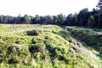
Cawthorne Camp is a Roman military fortification dating to the late first or early second century AD located near Pickering in the North York Moors. The site contains two distinct forts connected by earthwork defenses that still form visible boundaries across the landscape.
The camp was likely constructed as a Roman training facility rather than a combat position, suggesting it served specialized purposes during the occupation. Archaeological finds indicate the Romans experimented with unconventional construction methods that departed from their standard military designs.
The excavation in 1905 revealed a significant Iron Age chariot burial and square barrows, indicating the area's importance before Roman occupation.
The site lies around 4 miles north of Pickering and is reached via maintained walking paths that cross the earthwork boundaries. Visitors should be prepared for uneven ground as the remains of the original fortifications are still visible across the landscape.
Excavations conducted in 1905 revealed an important Iron Age chariot burial and square barrows, demonstrating the area held significance before Roman occupation arrived. These discoveries suggest the Romans chose a location where local populations had already established their own structures and traditions.
The community of curious travelers
AroundUs brings together thousands of curated places, local tips, and hidden gems, enriched daily by 60,000 contributors worldwide.