Church of Saint Pancras, Widecombe-in-the-Moor

Log in to your account

AroundUs is a community-driven map of interesting places, built by curious explorers like you. It grows with every review, story, and photo you share.
Connect to save your favorite spots, contribute locations, and create personalized routes.
By continuing, you accept our Terms and Conditions and our Privacy Policy

Church of Saint Pancras, Widecombe-in-the-Moor

Add to collection
Map
Suggest a change
Share

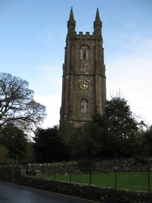
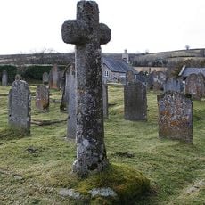
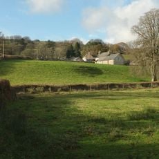
Church of Saint Pancras, Widecombe-in-the-Moor, Gothic church in Widecombe-in-the-Moor, England.

The Church of Saint Pancras features a 120-foot tower constructed from local granite and stands prominently within Dartmoor National Park.

Built around 1450, the church expanded over two centuries using funds from the local tin-mining industry that supported the region's economy.

The church ceiling displays intricate roof bosses, including the Three Hares symbol, which represents the connection to local tin miners.

The building maintains regular worship services and welcomes visitors to explore its architectural features and historical monuments throughout the week.

In 1638, a severe lightning strike damaged the church during a service, causing four deaths and leading to extensive reconstruction work.

Location: Widecombe in the Moor

Inception: 15 century

GPS coordinates: 50.57680,-3.81090

Latest update: March 7, 2025 04:17

Around this place
Show the full map
Ring cairn south west of Hound Tor, 215m east of East Lodge
United Kingdom

Ring cairn south west of Hound Tor, 215m east of East Lodge

3 km
Base Of Former Village Cross, About 10 Metres South Of Church House
United Kingdom

Base Of Former Village Cross, About 10 Metres South Of Church House

60 m
Rugglestone Inn
United Kingdom

Rugglestone Inn

328 m
The Old Inn
United Kingdom

The Old Inn

70 m
Venton Bridge
United Kingdom

Venton Bridge

209 m
Blackslade Farmhouse  Blackslade Manor Farm
United Kingdom

Blackslade Farmhouse Blackslade Manor Farm

1.5 km
Clapper Bridge On The Road From Widecombe Village To Natsworthy, About 130 Metres North East Of Wooder Manor
United Kingdom

Clapper Bridge On The Road From Widecombe Village To Natsworthy, About 130 Metres North East Of Wooder Manor

1 km
Cross About 5 Metres South Of South Transept Of St Pancras Church
United Kingdom

Cross About 5 Metres South Of South Transept Of St Pancras Church

23 m
Windwhistle
United Kingdom

Windwhistle

2.3 km
Clapper bridge about 60 metres south east of West Shallowford Farmhouse
United Kingdom

Clapper bridge about 60 metres south east of West Shallowford Farmhouse

2.9 km
Hameldown Beacon barrow
United Kingdom

Hameldown Beacon barrow

2.4 km
Folly About 115 Metres West Of Scoitor Farmhouse
United Kingdom

Folly About 115 Metres West Of Scoitor Farmhouse

1.9 km
Barn About 20 Metres South Of Bowden Farmhouse
United Kingdom

Barn About 20 Metres South Of Bowden Farmhouse

3.3 km
Hedge Barton Farmhouse
United Kingdom

Hedge Barton Farmhouse

2.6 km
Middle Bonehill Farmhouse, Including Garden Wall In Front Of Right Hand Side Of House
United Kingdom

Middle Bonehill Farmhouse, Including Garden Wall In Front Of Right Hand Side Of House

977 m
Dunstone Manor
United Kingdom

Dunstone Manor

1 km
Saxon Well, About 25 Metres West Of The Vicarage Gate On The Opposite Side Of The Road
United Kingdom

Saxon Well, About 25 Metres West Of The Vicarage Gate On The Opposite Side Of The Road

116 m
Gate Piers And Quadrant Walls About 15 Metres West Of The Vicarage, Together With Mounting Block 1 Metre South West Of The South Pier
United Kingdom

Gate Piers And Quadrant Walls About 15 Metres West Of The Vicarage, Together With Mounting Block 1 Metre South West Of The South Pier

105 m
Dunstone Cross
United Kingdom

Dunstone Cross

974 m
Direction Post At North East Side Of Hemsworthy Gate Crossroads
United Kingdom

Direction Post At North East Side Of Hemsworthy Gate Crossroads

2.4 km
Stentifords Cross, About 70 Metres South East Of Hemsworthy Gate Crossroads
United Kingdom

Stentifords Cross, About 70 Metres South East Of Hemsworthy Gate Crossroads

2.5 km
Cross At North Corner Of Crossroads About 250 Metres South West Of Dockwell Farmhouse
United Kingdom

Cross At North Corner Of Crossroads About 250 Metres South West Of Dockwell Farmhouse

2.3 km
Southcombe Farmhouse
United Kingdom

Southcombe Farmhouse

595 m
Bowden Farmhouse
United Kingdom

Bowden Farmhouse

3.2 km
Treemills Including Barn And Shippon At Left Hand End
United Kingdom

Treemills Including Barn And Shippon At Left Hand End

992 m
Swallerton Gate
United Kingdom

Swallerton Gate

3.1 km
Guidestone, Stone Cross, Cockingford
United Kingdom

Guidestone, Stone Cross, Cockingford

2.3 km
Milestone, 25m N of Stouts
United Kingdom

Milestone, 25m N of Stouts

1.3 km
Show the full map

Reviews

Visited this place? Tap the stars to rate it and share your experience / photos with the community! Try now! You can cancel it anytime.

« Church of Saint Pancras, Widecombe-in-the-Moor - Gothic church in Widecombe-in-the-Moor, England » is provided by Around Us (aroundus.com). Images and texts are derived from Wikimedia project under a Creative Commons license. You are allowed to copy, distribute, and modify copies of this page, under the conditions set by the license, as long as this note is clearly visible.

Discover hidden gems everywhere you go!

From secret cafés to breathtaking viewpoints, skip the crowded tourist spots and find places that match your style. Our app makes it easy with voice search, smart filtering, route optimization, and insider tips from travelers worldwide. Download now for the complete mobile experience.

Around Us App Screenshot

A unique approach to discovering new places

Le Figaro

All the places worth exploring

France Info

A tailor-made excursion in just a few clicks

20 Minutes