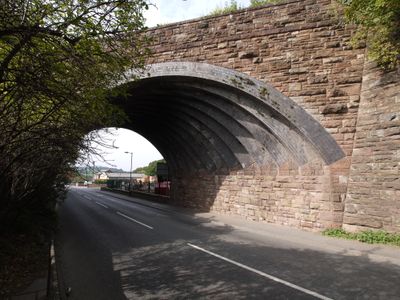
Hereford Road Skew Bridge, Railway arch bridge in Ledbury, England
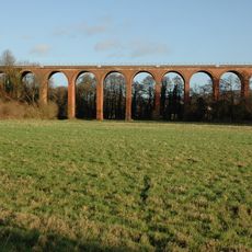
Hereford Road Skew Bridge is a brick arch bridge in Ledbury featuring thirteen staggered ribs made of blue brick. The ribs are arranged to distribute weight across its angled structure, creating a distinctive appearance as it crosses the road at an angle.
The bridge was built in 1881 for the Ledbury and Gloucester Railway and remained in operation until the line closed in 1959. After the railway shut down, it was converted for pedestrian use and integrated into local walking routes.
The bridge design represents nineteenth-century engineering methods, demonstrating the evolution of railway infrastructure during Britain's industrial development.
The bridge is accessible via the Ledbury Town Trail footpath and makes for an interesting walking stop to explore the area's industrial history. Approach from the road level to appreciate the full view of the ribbed arch structure and its angled design.
The structure crosses the road at a 45-degree angle, requiring specialized construction techniques to evenly distribute forces across its ribbed arch. This unusual slant design makes it a notable example of Victorian engineering in the region.
Location: Ledbury
Official opening: 1885
Made from material: brick, stone
GPS coordinates: 52.04500,-2.42860
Latest update: December 14, 2025 14:25
Church of St Michael and All Angels, including the detached Bell Tower, Ledbury
1 km
Market House
978 m
The Feathers Hotel
1.1 km
Horseshoe Inn
786 m
The Church House
1 km
1, Church Street
951 m
Brewery Inn
918 m
Old Talbot Inn
1.1 km
Ledbury Viaduct
569 m
Barrett Browning Institute
937 m
The Town Council Offices
968 m
Butcher Row House Museum
994 m
The Old Grammar School
989 m
8, High Street
1 km
Prince Of Wales Inn
974 m
St Katherine's Hospital And Almshouses
981 m
Garden Wall South And West Of Lower Hall
1 km
Magistrates' House And Number 1, 2 And 3 Magistrates' Court
986 m
Milestone At National Grid Reference So 7031 3860
398 m
Ledbury War Memorial
983 m
Shell House
808 m
St Cuthbert's
780 m
Tudor House
1.1 km
Public Lavatories
973 m
9, High Street
1 km
Former Sargents House
970 m
Milestone At National Grid Refernce So 7070 3911
506 m
The Steppes
1.1 kmVisited this place? Tap the stars to rate it and share your experience / photos with the community! Try now! You can cancel it anytime.
Discover hidden gems everywhere you go!
From secret cafés to breathtaking viewpoints, skip the crowded tourist spots and find places that match your style. Our app makes it easy with voice search, smart filtering, route optimization, and insider tips from travelers worldwide. Download now for the complete mobile experience.
A unique approach to discovering new places❞
— Le Figaro
All the places worth exploring❞
— France Info
A tailor-made excursion in just a few clicks❞
— 20 Minutes