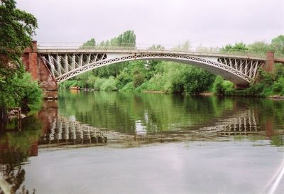
Holt Fleet Bridge, Road bridge in Holt and Ombersley, England.
Holt Fleet Bridge is a stone structure that carries traffic across the River Severn, joining the two settlements on either bank. The construction allows vehicles and pedestrians to move freely between Holt and Ombersley.
Thomas Telford designed and built this bridge in 1828 during the early stages of modern infrastructure development in Britain. The structure has remained substantially unchanged since its completion, preserving the engineering approach of that era.
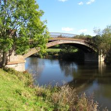
The bridge is woven into daily life for residents of both Holt and Ombersley, serving as a vital crossing point used by locals for work and community activities. It stands as a physical symbol of how two neighboring communities depend on shared infrastructure to remain connected.
The bridge is accessible as an active road route and can be crossed on foot or by vehicle at any time. Visitors should expect regular traffic and plan their crossing accordingly.
The bridge displays distinctive design features from Telford's engineering philosophy, emphasizing long-lasting construction methods. Many original stone details and structural elements remain visible, offering insight into 19th-century bridge building techniques.
Location: Holt
Location: Ombersley
GPS coordinates: 52.26799,-2.25889
Latest update: December 14, 2025 12:25
Bowling Green Inn
4 km
The Venture Inn
2.1 km
Holt Castle
1 km
Church of St Bartholomew's
2.9 km
Church of St Andrew, Ombersley
2 km
Church of St Martin, Holt
951 m
Church of St Michael
4.2 km
Church of St Mary
4.5 km
Church of St Mary, Shrawley
2.3 km
Bevere Bridge
4.1 km
King's Arms Public House
2.1 km
Ombersley War Memorial
2.1 km
Ombersley Court
1.8 km
Linacre Bridge
4.1 km
Hawford Dovecote
3.5 km
Milestone, jct with A4133; 20m N of junc with old road thro' Ombersley
2.2 km
Mill Hall
4.7 km
The Dower House
2 km
Crown And Sandys Arms
2.1 km
Churchyard cross, St Mary's Church
2.3 km
Milestone, Hawford Wood, N-bound carriageway at SO8444661092
3 km
Milestone, Hawford Wood, N-bound carriageway at SO8444161102
3 km
Milestone, opp drive to park
3.3 km
Milestone, entrance to Top Barn, Quarry Pools
2 km
Milestone, Elm Cottages
937 m
Milestone, W of Hazeldene, opp bungalow 100m W of junc for Ockeridge
1.9 km
Milestone, E of Little Witley, E of new houses where the was an old petrol station
3.4 km
Milestone, Shrawley villge, by village hall
2.6 kmVisited this place? Tap the stars to rate it and share your experience / photos with the community! Try now! You can cancel it anytime.
Discover hidden gems everywhere you go!
From secret cafés to breathtaking viewpoints, skip the crowded tourist spots and find places that match your style. Our app makes it easy with voice search, smart filtering, route optimization, and insider tips from travelers worldwide. Download now for the complete mobile experience.
A unique approach to discovering new places❞
— Le Figaro
All the places worth exploring❞
— France Info
A tailor-made excursion in just a few clicks❞
— 20 Minutes