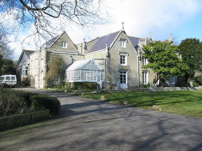
Leeson House, Grade II listed building in Langton Matravers, England
Leeson House is a protected country house in Langton Matravers that functions as an environmental education center and encompasses seven acres of varied habitats including ponds, meadows, and woodlands. The building features two dining rooms, several lounges, a conference hall, and teaching spaces equipped with a field laboratory.
The house was built in 1805 by Reverend John Dampier on land previously noted in the Domesday Book. During World War II it later served as a radar research facility.
The building reflects early 19th century architectural methods and residential design traditions of England as a protected structure. It represents a chapter in the English country house heritage of that period.
The location sits within the Purbeck area and is designed for school groups and field study visits, with accommodation available for roughly 60 people. The mix of indoor teaching spaces and outdoor grounds makes it possible to conduct lessons both inside and outside.
Since 1967 the renovated building has functioned as an environmental education center, regularly drawing school groups for hands-on learning in nature and science. This transformation from the original residence to a modern learning space has fundamentally shifted the place's role in education.
Location: Langton Matravers
GPS coordinates: 50.60770,-1.99444
Latest update: December 13, 2025 11:42
Swanage Railway
1.1 km
The Town Hall
2.5 km
Swanage Museum & Heritage Centre
2.7 km
Parish Church of Saint George
698 m
St Mark's Church
1.3 km
Parish Church
2.2 km
The Anchor Inn
2.6 km
Ship Hotel
2.7 km
Purbeck House (Convent Of Our Lady Of Mercy)
2.4 km
King Alfred Memorial
2.6 km
Swanage Museum
2.7 km
The Mowlem
2.7 km
Purbeck Hotel
2.7 km
Swanage Library
2.6 km
Swanage War Memorial
2.6 km
The White Swan
2.7 km
The Methodist Church And Hall Immediately East And Boundary Walls To West And North
2.4 km
K6 Telephone Kiosk Outside No 19, High Street (Purbeck Hotel)
2.7 km
Lloyds Bank
2.6 km
The Old Water Tower
2.8 km
Eldon Terrace Including Garden Area Walls And No.13 Kings Road East
2.5 km
15-21 Kings Road East
2.5 km
Two K6 Telephone Boxes Outside Library
2.6 km
Stone Steps To Cliff Place Leading Up From The High Street
2.7 km
1 and 2, Cliff Place
2.8 km
Milestone, 150m W of turning to Worth Matravers
1.8 km
Milestone, Langton Matravers; 30M W of Ship Inn
359 m
Milestone, High Street, between Bell St and Steer Rd
1.3 kmVisited this place? Tap the stars to rate it and share your experience / photos with the community! Try now! You can cancel it anytime.
Discover hidden gems everywhere you go!
From secret cafés to breathtaking viewpoints, skip the crowded tourist spots and find places that match your style. Our app makes it easy with voice search, smart filtering, route optimization, and insider tips from travelers worldwide. Download now for the complete mobile experience.
A unique approach to discovering new places❞
— Le Figaro
All the places worth exploring❞
— France Info
A tailor-made excursion in just a few clicks❞
— 20 Minutes