Chest opened
+${chestReward.xp} XP
Explorer
NOUVEAU ×${chestReward.collectible.quantity}
tapez pour fermer
Chest locked

Open chests in the app

Around Us is built for your phone — chests unlock when you walk, explore and capture nearby places.

Enable Location

We need your location to show you interesting places around you

Discover nearby places

Find interesting locations and hidden gems around you

Precise directions

Get accurate directions and distances to places

Your location is never shared with other users. It's only used when you tap the location button.

Lambrigg Fell

Log in to your account

Start exploring — it's free

Trusted by 72,878 travelers worldwide

Continue with Google
Continue with Apple
or

We will send you a code to connect

By continuing, you accept our Terms and Conditions and our Privacy Policy

Check your inbox

We've sent a pincode in your inbox. Please enter the code below.

Lambrigg Fell
Discussion Reviews 1 Photos
1.4k Popularity

Lambrigg Fell, Mountain summit in Cumbria, England

Lambrigg Fell is a mountain summit in Cumbria that rises to 339 meters above sea level, representing the highest point between Kendal and the M6 motorway in the southeastern part of the region. The gentle, grass-covered slopes give this place an open character with wide views across the surrounding terrain.

A shelter structure located about 100 meters west of the summit recalls hunting parties that visited this mountain centuries ago. These remains show how people have used this land for hunting throughout history.

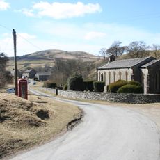
This fell sits outside the Lake District boundaries and features grassland moorland that looks noticeably different from the rocky peaks typical of the region. Visitors walking here notice how the gentle slopes feel distinct from the landscape they expect in the Lake District.

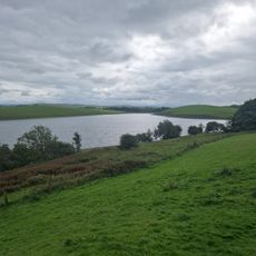
Access to the summit follows a track that passes a small reservoir, though the landowner restricts entry beyond the highest sheepfold on the path. Visitors should be aware of these boundaries and stick to marked routes to avoid trespassing on private land.

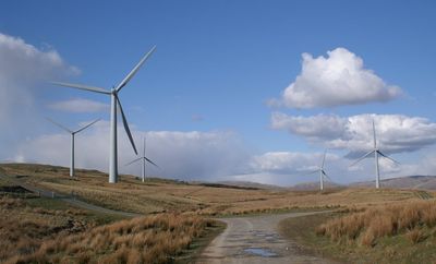
A wind farm operating near the summit since 2000 generates 6.5 megawatts of power and was England's most significant wind facility of its era. This installation marks the transformation of the mountain into a site of renewable energy production.

The community of curious travelers

AroundUs brings together thousands of curated places, local tips, and hidden gems, enriched daily by 60,000 contributors worldwide.

Start exploring
Location
Elevation above the sea
339 m
GPS coordinates
54.34111,-2.63823
Latest update
December 14, 2025 17:02
Around this place
St Gregory's Church, Vale of Lune
United Kingdom

St Gregory's Church, Vale of Lune

5.2 km
Holy Trinity Church, Howgill
United Kingdom

Holy Trinity Church, Howgill

4.8 km
Killington Reservoir
United Kingdom

Killington Reservoir

3.3 km
Church of St John
United Kingdom

Church of St John

4.2 km
Church of St John
United Kingdom

Church of St John

3.1 km
Church of St Stephen
United Kingdom

Church of St Stephen

3.7 km
St John the Baptist's Church
United Kingdom

St John the Baptist's Church

5.8 km
Banty Gill Bridge
United Kingdom

Banty Gill Bridge

4.9 km
Killington New Bridge
United Kingdom

Killington New Bridge

4.9 km
Crook of Lune Bridge
United Kingdom

Crook of Lune Bridge

4.1 km
Milestone Approximately 40M From A685
United Kingdom

Milestone Approximately 40M From A685

5.5 km
Waterside Viaduct
United Kingdom

Waterside Viaduct

4.6 km
Howgill War Memorial
United Kingdom

Howgill War Memorial

4.8 km
Milepost Approx 100M West Of Bridge End
United Kingdom

Milepost Approx 100M West Of Bridge End

4.8 km
Docker Viaduct
United Kingdom

Docker Viaduct

2.5 km
K6 telephone kiosk approximately 20 metres south east of Holy Trinity churchyard
United Kingdom

K6 telephone kiosk approximately 20 metres south east of Holy Trinity churchyard

4.9 km
Milestone At Sd 628 933
United Kingdom

Milestone At Sd 628 933

4.4 km
Milestone At Sd 617 961
United Kingdom

Milestone At Sd 617 961

3.7 km
Milestone At Sd 616 974
United Kingdom

Milestone At Sd 616 974

4.5 km
Milestone On East Side Of Lane Approximately 30 Metres South Of Fairmile Beck
United Kingdom

Milestone On East Side Of Lane Approximately 30 Metres South Of Fairmile Beck

5.6 km
Milestone on south of road approximately 100 metres east of Killington New Bridge
United Kingdom

Milestone on south of road approximately 100 metres east of Killington New Bridge

5 km
Lowgill Viaduct
United Kingdom

Lowgill Viaduct

3.8 km
Milestone At Sd 624 947
United Kingdom

Milestone At Sd 624 947

3.9 km
Milestone Approximately 130M To West Of Gillhouse Style
United Kingdom

Milestone Approximately 130M To West Of Gillhouse Style

3.9 km
Lowgill Packhorse Bridge
United Kingdom

Lowgill Packhorse Bridge

3.8 km
Milestone, Hutton crossroads, Woodside
United Kingdom

Milestone, Hutton crossroads, Woodside

3 km
Milestone, Fisher Tarn Reservoir
United Kingdom

Milestone, Fisher Tarn Reservoir

4 km
Milestone, carved stone post, S of Sedbergh
United Kingdom

Milestone, carved stone post, S of Sedbergh

5.5 km
Show the full map
Reviews
Share your experience

No review yet

Discussions
Start a discussion...

No discussion yet

« Lambrigg Fell - Mountain summit in Cumbria, England » is provided by Around Us (aroundus.com). Images and texts are derived from Wikimedia project under a Creative Commons license. You are allowed to copy, distribute, and modify copies of this page, under the conditions set by the license, as long as this note is clearly visible.

Discover hidden gems everywhere you go!

From secret cafés to breathtaking viewpoints, skip the crowded tourist spots and find places that match your style. Our app makes it easy with voice search, smart filtering, route optimization, and insider tips from travelers worldwide. Download now for the complete mobile experience.

Around Us App Screenshot

A unique approach to discovering new places

Le Figaro

All the places worth exploring

France Info

A tailor-made excursion in just a few clicks

20 Minutes

Around Us
Travel Guide & Maps
Download

Send to your phone

QR Code
1

Open the camera app on your mobile.

2

Point at the QR code with your camera. A notification will appear.

3

Tap the notification to open the link.