Lescudjack Hill Fort, Iron Age fort in Penzance, United Kingdom
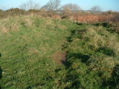
Lescudjack Hill Fort is an Iron Age fortification situated on a steep hill in Penzance, surrounded by circular ramparts. The site covers approximately 3 acres and displays typical Iron Age settlement features with defensive characteristics.
The fortification was built around 300 BC and served as the largest Iron Age fortified settlement in the Cornwall region. It marks an important phase of Iron Age occupation in southwest England.
The name Lescudjack comes from Cornish language and refers to a sheltered enclosure or a wooded valley. The site remains connected to the local identity and heritage of Cornwall.
The site is accessible via public footpaths, though some areas are steep and require sturdy footwear. The grounds are open year-round, but southwest England's weather can be changeable, so appropriate clothing is advisable.
A small lead-copper mine operated outside the ramparts, demonstrating this location's connection to Cornwall's mining history. This makes the site notable as it combined settlement with resource extraction.
Location: Penzance
GPS coordinates: 50.12550,-5.53351
Latest update: December 9, 2025 12:22
Roman Catholic Church of the Immaculate Conception of Our Lady
476 m
St Paul's Church, Penzance
725 m
Church of St John the Baptist
260 m
St Erbyn's School
731 m
Crown Inn
507 m
Davy Monument
759 m
Coombe Cottage
274 m
58-60, Adelaide Street
482 m
2-18, Victoria Square
529 m
42, Market Jew Street
490 m
48-50, Market Jew Street
451 m
Gothic House
463 m
40 And 41, Market Place
743 m
38 And 39, Market Place
752 m
57, Adelaide Street
479 m
Conduit Head In Wall Of No 37
386 m
13 And 14, Market Jew Street
676 m
83, Market Jew Street
547 m
18, Market Jew Street
636 m
5, Market Jew Street
724 m
Warehouse Occupied By Courts (Furnishers)
519 m
Raised Pavement, Steps And Railings
640 m
Boundary Stone In Front Of No. 8 Chyandour Cliff
287 m
1 and 2, Market Jew Street
737 m
2-6, Leskinnick Street
380 m
Former Coach Sheds And Workshops (Forming Part Of Victoria Garage In Bread Street)
535 m
Guidestone, Gear Hill, jct with Tannack Road, Newhill turn
722 m
Guidestone, Green Lane Hill, T jct with Polmennor Road, opp. Gulval village sign
595 mVisited this place? Tap the stars to rate it and share your experience / photos with the community! Try now! You can cancel it anytime.
Discover hidden gems everywhere you go!
From secret cafés to breathtaking viewpoints, skip the crowded tourist spots and find places that match your style. Our app makes it easy with voice search, smart filtering, route optimization, and insider tips from travelers worldwide. Download now for the complete mobile experience.
A unique approach to discovering new places❞
— Le Figaro
All the places worth exploring❞
— France Info
A tailor-made excursion in just a few clicks❞
— 20 Minutes