Madley Communications Centre

Log in to your account

AroundUs is a community-driven map of interesting places, built by curious explorers like you. It grows with every review, story, and photo you share.
Connect to save your favorite spots, contribute locations, and create personalized routes.
By continuing, you accept our Terms and Conditions and our Privacy Policy

Madley Communications Centre

Add to collection
Map
Suggest a change
Share

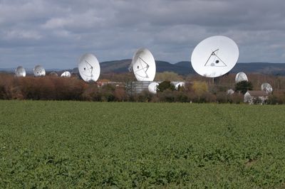
Madley Communications Centre, Satellite tracking station in Kingstone, England

Madley Communications Centre is a satellite receiving station spread across extensive grounds with many dish antennas of varying sizes. The facility uses its natural location to protect the large receiving equipment from interference while processing signals from space.

The site was originally a Royal Air Force military airfield before being converted for satellite communications in the 1970s. This transformation marked a significant shift from military to civilian telecommunications use.

The site played a key role in connecting distant parts of the world through satellite technology when it opened. Walking around, you notice how the numerous dishes work together to relay signals across continents.

The grounds are expansive, so comfortable footwear and advance planning are recommended for a good visit. Views of the different antennas are accessible from several spots across the property, though weather and time of day affect what you can see.

The location was carefully chosen because its geological features help keep electronic signals clear and undistorted. This natural shielding is one reason the site performs better than other possible locations.

Location: Kingstone

Inception: 2015

GPS coordinates: 52.03200,-2.84049

Latest update: December 8, 2025 20:02

Photos
Around this place
Show the full map
The Weir Garden
United Kingdom

The Weir Garden

4.7 km
Church of St Dubricius, at St Devereux, Herefordshire
United Kingdom

Church of St Dubricius, at St Devereux, Herefordshire

6.4 km
Church of the Nativity of the Blessed Virgin Mary
United Kingdom

Church of the Nativity of the Blessed Virgin Mary

1.4 km
Church of St Andrew
United Kingdom

Church of St Andrew

4.5 km
Church of St Michael and All Angels
United Kingdom

Church of St Michael and All Angels

1.7 km
Church of St Michael and All Angels
United Kingdom

Church of St Michael and All Angels

2.5 km
Church of St Michael
United Kingdom

Church of St Michael

5.3 km
Church of All Saints, Clehonger
United Kingdom

Church of All Saints, Clehonger

4.1 km
Church of St Bartholomew
United Kingdom

Church of St Bartholomew

3.1 km
Milestone At So 449322
United Kingdom

Milestone At So 449322

5.9 km
Wayside cross at NGR SO 420388
United Kingdom

Wayside cross at NGR SO 420388

1.5 km
Milestone At Ngr So 463362
United Kingdom

Milestone At Ngr So 463362

4.1 km
Milestone At Ngr So 462362
United Kingdom

Milestone At Ngr So 462362

4 km
Didley Court Farmhouse
United Kingdom

Didley Court Farmhouse

6 km
Milestone At Ngr So 475373
United Kingdom

Milestone At Ngr So 475373

5.1 km
Milepost, Coldwell; 30m E jcn B4348, W of Kingstone School
United Kingdom

Milepost, Coldwell; 30m E jcn B4348, W of Kingstone School

1.6 km
Milepost At Ngr So 397388
United Kingdom

Milepost At Ngr So 397388

3.1 km
Milepost, Morehampton Park; 140m N Farmhouse Farm entrance
United Kingdom

Milepost, Morehampton Park; 140m N Farmhouse Farm entrance

5.7 km
Milepost, Clehonger Court
United Kingdom

Milepost, Clehonger Court

4.9 km
Milepost, Showel Farm; opp. nursery
United Kingdom

Milepost, Showel Farm; opp. nursery

1.8 km
Milepost, Woodyatt's Cross; 100m E of cross
United Kingdom

Milepost, Woodyatt's Cross; 100m E of cross

1 km
Milepost, by Bowley Farm
United Kingdom

Milepost, by Bowley Farm

1.9 km
Milepost, opp. jct of Gosmore Road
United Kingdom

Milepost, opp. jct of Gosmore Road

3.4 km
Milepost, Cagebrook House, top of hill at entrance to Woodlands Farm
United Kingdom

Milepost, Cagebrook House, top of hill at entrance to Woodlands Farm

1.9 km
Milepost, Church View, The Rhydd (ruined property)
United Kingdom

Milepost, Church View, The Rhydd (ruined property)

6.2 km
Milepost, Breinton Common, by Beechcroft Bungalow
United Kingdom

Milepost, Breinton Common, by Beechcroft Bungalow

3.7 km
Milepost, Willox Bridge; E of A465 jcn
United Kingdom

Milepost, Willox Bridge; E of A465 jcn

4.9 km
Milepost, Hanley Court
United Kingdom

Milepost, Hanley Court

1.6 km
Show the full map
Reviews

Visited this place? Tap the stars to rate it and share your experience / photos with the community! Try now! You can cancel it anytime.

« Madley Communications Centre - Satellite tracking station in Kingstone, England » is provided by Around Us (aroundus.com). Images and texts are derived from Wikimedia project under a Creative Commons license. You are allowed to copy, distribute, and modify copies of this page, under the conditions set by the license, as long as this note is clearly visible.

Discover hidden gems everywhere you go!

From secret cafés to breathtaking viewpoints, skip the crowded tourist spots and find places that match your style. Our app makes it easy with voice search, smart filtering, route optimization, and insider tips from travelers worldwide. Download now for the complete mobile experience.

Around Us App Screenshot

A unique approach to discovering new places

Le Figaro

All the places worth exploring

France Info

A tailor-made excursion in just a few clicks

20 Minutes