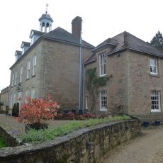
Mawley Hall, Georgian country house in Cleobury Mortimer, England
Mawley Hall is a red brick house built in 1730 featuring nine window bays with large Tuscan pillars and sandstone trim. The building has a double staircase with wrought iron railings and inside contains plasterwork of the highest quality combined with elegant rooms in the Adam style.
The architect Francis Smith of Warwick built the house in 1730 for Sir Edward Blount, a member of a well-known Catholic family. The family had restored their wealth after the English Civil War and commissioned this grand house as a sign of their recovered position.
The name comes from the surrounding landscape, while the rooms inside show Baroque decoration and Georgian style. Visitors can see how the fine plasterwork and classical design reflect the wealth and taste of an important family from the 1700s.
The estate sits within a landscape of fields, woodland, and a golf course that visitors can explore. Access to the gardens and outdoor areas is usually available, though it is wise to check in advance which areas are open to visitors.
In the 1960s new gardens were created with a rhododendron avenue and an octagonal pavilion built in 1973. These later additions gave the estate a new layer that extends beyond its original Georgian design.
The community of curious travelers
AroundUs brings together thousands of curated places, local tips, and hidden gems, enriched daily by 60,000 contributors worldwide.