Enable Location

We need your location to show you interesting places around you

Discover nearby places

Find interesting locations and hidden gems around you

Precise directions

Get accurate directions and distances to places

Your location is never shared with other users. It's only used when you tap the location button.

Mile End Stadium

Log in to your account

Start exploring — it's free

Trusted by 63,013 travelers worldwide

Continue with Google
Continue with Apple
or

We will send you a code to connect

By continuing, you accept our Terms and Conditions and our Privacy Policy

Check your inbox

We've sent a pincode in your inbox. Please enter the code below.

Mile End Stadium
Discussion Reviews 1 Photos
6.1k Popularity

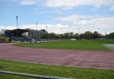
Mile End Stadium, Sports complex in Mile End, England.

Mile End Stadium is a sports complex with multiple facilities including an athletics track, floodlit football fields, tennis courts, and a modern swimming center with a 25-meter pool. The site combines different sports areas that serve both competitors and visitors throughout the year.

The stadium opened in 1990 as a major addition to East London's sports facilities. This development reflected the area's commitment to improving recreational infrastructure during that decade.

The venue is home to two local football clubs that play in the Eastern Counties Football League and draw supporters from the surrounding neighborhoods.

The site is well served by public transportation with numerous bus routes and the nearby Mile End tube station. Access to Cycle Superhighway CS2 makes it accessible by bicycle as well.

In 1995, the stadium hosted a major concert featuring the band Blur that attracted tens of thousands of visitors and showed the venue could serve purposes beyond sports. This event highlighted the flexibility of the space for different kinds of gatherings.

The community of curious travelers

AroundUs brings together thousands of curated places, local tips, and hidden gems, enriched daily by 60,000 contributors worldwide.

Start exploring
Inception
September 9, 1990
Official opening
September 9, 1990
GPS coordinates
51.51901,-0.03342
Latest update
December 10, 2025 16:21
Around this place
Tower Hamlets Cemetery
United Kingdom

Tower Hamlets Cemetery

608 m
St Dunstan's, Stepney
United Kingdom

St Dunstan's, Stepney

616 m
Ragged School Museum
United Kingdom

Ragged School Museum

160 m
St Paul's Bow Common
United Kingdom

St Paul's Bow Common

317 m
Ackroyd Drive Greenlink
United Kingdom

Ackroyd Drive Greenlink

300 m
Johnson's Lock
United Kingdom

Johnson's Lock

216 m
The Guardian Angels Roman Catholic Church
United Kingdom

The Guardian Angels Roman Catholic Church

676 m
Salmon Lane Lock
United Kingdom

Salmon Lane Lock

468 m
Iron Railings, Gate Piers And Gates At St Dunstan's Churchyard
United Kingdom

Iron Railings, Gate Piers And Gates At St Dunstan's Churchyard

677 m
St Benet's Chapel
United Kingdom

St Benet's Chapel

640 m
Stepney War Memorial
United Kingdom

Stepney War Memorial

661 m
Professional Development Centre (Formerly South Grove School), With Associated Handicraft/Woodwork Block, Boundary Wall And Iron Gates
United Kingdom

Professional Development Centre (Formerly South Grove School), With Associated Handicraft/Woodwork Block, Boundary Wall And Iron Gates

396 m
Tomb Of Joseph Westwood
United Kingdom

Tomb Of Joseph Westwood

604 m
Gate Piers And Overthrow At Lady Mico's Almshouses
United Kingdom

Gate Piers And Overthrow At Lady Mico's Almshouses

643 m
50 And 52, Belgrave Street E1
United Kingdom

50 And 52, Belgrave Street E1

686 m
Tomb Of Ellen Wiskin
United Kingdom

Tomb Of Ellen Wiskin

588 m
46 And 48, Copperfield Road E3
United Kingdom

46 And 48, Copperfield Road E3

163 m
Bromley-by-Bow War Memorial
United Kingdom

Bromley-by-Bow War Memorial

482 m
Tomb Of John Smith
United Kingdom

Tomb Of John Smith

585 m
Tomb Of Ellen Llewellyn
United Kingdom

Tomb Of Ellen Llewellyn

593 m
Tomb Of Samuel Weddell
United Kingdom

Tomb Of Samuel Weddell

595 m
3-19, Durham Row E1
United Kingdom

3-19, Durham Row E1

541 m
16-21, Flamborough Street E1
United Kingdom

16-21, Flamborough Street E1

671 m
9-15, Flamborough Street E1
United Kingdom

9-15, Flamborough Street E1

668 m
Drinking fountain and clock tower at Queen Mary College
United Kingdom

Drinking fountain and clock tower at Queen Mary College

653 m
Tomb Of Sarah Morris And George Morris
United Kingdom

Tomb Of Sarah Morris And George Morris

599 m
Boundary Wall, Gates And Gate Piers To Tower Hamlets Cemetery
United Kingdom

Boundary Wall, Gates And Gate Piers To Tower Hamlets Cemetery

554 m
South East And South West Boundary Walls To Jewish Burial Ground
United Kingdom

South East And South West Boundary Walls To Jewish Burial Ground

667 m
Show the full map
Reviews
Share your experience

No review yet

Discussions
Start a discussion...

No discussion yet

« Mile End Stadium - Sports complex in Mile End, England » is provided by Around Us (aroundus.com). Images and texts are derived from Wikimedia project under a Creative Commons license. You are allowed to copy, distribute, and modify copies of this page, under the conditions set by the license, as long as this note is clearly visible.

Discover hidden gems everywhere you go!

From secret cafés to breathtaking viewpoints, skip the crowded tourist spots and find places that match your style. Our app makes it easy with voice search, smart filtering, route optimization, and insider tips from travelers worldwide. Download now for the complete mobile experience.

Around Us App Screenshot

A unique approach to discovering new places

Le Figaro

All the places worth exploring

France Info

A tailor-made excursion in just a few clicks

20 Minutes

Around Us
Travel Guide & Maps
Download

Send to your phone

QR Code
1

Open the camera app on your mobile.

2

Point at the QR code with your camera. A notification will appear.

3

Tap the notification to open the link.