Packington Hall

Log in to your account

AroundUs is a community-driven map of interesting places, built by curious explorers like you. It grows with every review, story, and photo you share.
Connect to save your favorite spots, contribute locations, and create personalized routes.
Continue with Google
Continue with Apple
Continue with X
Continue with Facebook
Continue with email
By continuing, you accept our Terms and Conditions and our Privacy Policy
Create an account
Add to collection
Map
Suggest a change
Share

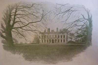
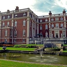
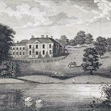
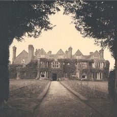
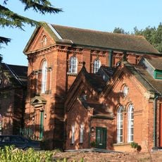
Packington Hall, Grade II listed house in Swinfen and Packington, England

Packington Hall is a country house in Swinfen and Packington featuring traditional architectural elements, including Palladian design influences and detailed ceiling paintings by John Francis Rigaud in the main rooms. The building displays carefully appointed interior spaces that reflect the tastes and wealth of its occupants.

The house was built in 1693 for Sir Clement Fisher and underwent major renovations in 1766 under architect Matthew Brettingham for the 3rd Earl of Aylesford. These improvements marked a turning point in how the house was redesigned and furnished.

The estate reflects how British aristocratic homes evolved over time, with stables and grounds shaped by renowned landscape architect Capability Brown. The rooms still show the mark of this historical design in how they are laid out and used.

The house remains private, but sections can be reserved for conferences and special events by arranging with the management in advance. If you wish to visit, it is best to check ahead since public access is limited.

The entrance gates from the A45 road were presented as a gift to the Earl of Aylesford by estate tenants in 1935. This gift shows the connection between the property and its local community at that time.

Location: Swinfen and Packington

GPS coordinates: 52.65420,-1.76080

Latest update: December 14, 2025 14:20

Photos
Around this place
Staffordshire Regiment Museum
United Kingdom

Staffordshire Regiment Museum

1.3 km
Swinfen Hall
United Kingdom

Swinfen Hall

2.8 km
Freeford Hall
United Kingdom

Freeford Hall

3 km
Whittington Old Hall
United Kingdom

Whittington Old Hall

1.9 km
St Chad's Church, Hopwas
United Kingdom

St Chad's Church, Hopwas

1.8 km
The Staffordshire Regiment Museum and Mercian Regiment Archive
United Kingdom

The Staffordshire Regiment Museum and Mercian Regiment Archive

1.3 km
Church of St Giles
United Kingdom

Church of St Giles

2.1 km
Church of St Mary
United Kingdom

Church of St Mary

3.2 km
Church of St Bartholomew
United Kingdom

Church of St Bartholomew

3.4 km
Former Hopwas Pumping Station (Spruce House, Cedar House And Holly House) And Front Boundary Wall
United Kingdom

Former Hopwas Pumping Station (Spruce House, Cedar House And Holly House) And Front Boundary Wall

1.6 km
Dunstall Farm Bridge
United Kingdom

Dunstall Farm Bridge

3.7 km
Coventry Canal Swan Bridge
United Kingdom

Coventry Canal Swan Bridge

2.6 km
Dunstall Bridge (That Part In Fazeley Civil Parish)
United Kingdom

Dunstall Bridge (That Part In Fazeley Civil Parish)

3.3 km
Hopwas Bridge
United Kingdom

Hopwas Bridge

2.2 km
Whittington War Memorial
United Kingdom

Whittington War Memorial

2 km
Hopwas War Memorial
United Kingdom

Hopwas War Memorial

1.8 km
Milepost At Ngr Sk 1968 0650
United Kingdom

Milepost At Ngr Sk 1968 0650

3.4 km
Birmingham And Fazeley Canal Tamhorn Farm Bridge
United Kingdom

Birmingham And Fazeley Canal Tamhorn Farm Bridge

2 km
Milepost, near Common Barn
United Kingdom

Milepost, near Common Barn

685 m
Milepost At Ngr Sk 1701 0297
United Kingdom

Milepost At Ngr Sk 1701 0297

3.4 km
L-Shaped Range Of Farm Outbuildings To The North West Of Bucks Head Farmhouse
United Kingdom

L-Shaped Range Of Farm Outbuildings To The North West Of Bucks Head Farmhouse

2.8 km
Milepost, Rock Hill, NW of Hints, just E of lane to quarry
United Kingdom

Milepost, Rock Hill, NW of Hints, just E of lane to quarry

2.9 km
Milepost, Hopwas, nr Plantation Lane jct
United Kingdom

Milepost, Hopwas, nr Plantation Lane jct

1.7 km
Milepost, Roman Road, N of Weeford Church
United Kingdom

Milepost, Roman Road, N of Weeford Church

3 km
Milepost, Weeford Lodge
United Kingdom

Milepost, Weeford Lodge

3.7 km
Milepost, SE of Coton
United Kingdom

Milepost, SE of Coton

3 km
Milepost, near Wittington Common Road jct with A51
United Kingdom

Milepost, near Wittington Common Road jct with A51

2.9 km
Milepost, near Wittington Barracks
United Kingdom

Milepost, near Wittington Barracks

1.4 km
Show the full map
Reviews

Visited this place? Tap the stars to rate it and share your experience / photos with the community! Try now! You can cancel it anytime.

« Packington Hall - Grade II listed house in Swinfen and Packington, England » is provided by Around Us (aroundus.com). Images and texts are derived from Wikimedia project under a Creative Commons license. You are allowed to copy, distribute, and modify copies of this page, under the conditions set by the license, as long as this note is clearly visible.

Discover hidden gems everywhere you go!

From secret cafés to breathtaking viewpoints, skip the crowded tourist spots and find places that match your style. Our app makes it easy with voice search, smart filtering, route optimization, and insider tips from travelers worldwide. Download now for the complete mobile experience.

Around Us App Screenshot

A unique approach to discovering new places

Le Figaro

All the places worth exploring

France Info

A tailor-made excursion in just a few clicks

20 Minutes