RNAS Inskip, Naval air station in Lancashire, England
RNAS Inskip is a former naval air station built on about 600 acres of converted farmland with four concrete runways and facilities designed to handle approximately 145 aircraft. The site contained barracks, maintenance hangars, and training buildings laid out across the airfield to support daily operations.
The Royal Navy acquired the land in 1942 and developed it into an operational airbase by 1943. The station primarily trained crews for anti-submarine warfare and strike operations during the Second World War.
The station served as a gathering place for the local community during wartime, allowing civilians from nearby towns to witness military aviation operations. This public dimension made the base part of the wider regional experience of the war effort.
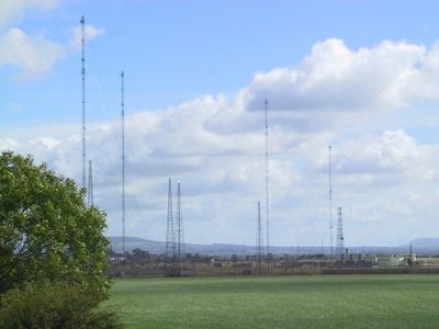
The site now operates as a communications facility with 90 radio masts, several reaching about 600 feet (180 m) tall and used for maritime transmissions. Much of the former airfield has been developed as an industrial park, so public access to the site is limited.
The former airfield retained its military identity as MOD Inskip while transitioning from flight operations to communications. Today the site hosts both military radio facilities and an adjacent industrial park called Nightjar Way, creating an unexpected mix of functions on the same location.
The community of curious travelers
AroundUs brings together thousands of curated places, local tips, and hidden gems, enriched daily by 60,000 contributors worldwide.